Nature is under pressure at this urban oasis, where fewer shorebirds now live around Union Bay, yet it still sustains hope.
DEEP WITHIN METROPOLIS, a rare grand view: open sky, a wide sweep of water where salmon run, bald eagles flying by at eye level, wildish-looking marsh below, mountains in every direction, Earth’s horizon nearly imaginable.
And yet, we have to wonder: When will we ask too much of this landscape, the place we live?
Our perch is new concrete and shiny steel overlooking Union Bay, about 3.2 miles from the Space Needle, on a trail that stretches across Lake Washington. It is a hard shoulder attached to the latest imposition in this fragile oasis, the replacement Highway 520 floating bridge. Traffic breathes its noise, vibrations and its own wind down our necks. Beyond the cattails and treetops, a wall of expensive homes encircles us, down to the waterline. Leaning over the railing, our gaze tracks wood ducks, pied-billed grebes and double-crested cormorants as they dive and pop back up where we do not expect. Young plants and fresh soil are arrayed in patterns only humans could design, covering scars from recent demolition and construction.
An update on Union Bay
Tom Reese’s new book, “Last Oasis: Revisiting Union Bay,” is available at blurb.com . The book is an update of his 2007 book about the bay.
As humans acclimating to our recent existential predicaments, it can seem newly natural to feel wonder and to worry at the same time. But this is time-honored wonder and worry; in 1951, Harry Higman and Earl Larrison explored and documented in their book, “Union Bay: The Life of a City Marsh,” the “competition between man and nature.” They wrote, “We watched the continual reconcilement of apparently unreconcilable things.”
<img data-caption="This view, with Waterfront Trail in the foreground, features Foster Island, Laurelhurst, Bellevue and the Cascades. (Tom Reese)" class='' alt='This view, with Waterfront Trail in the foreground, features Foster Island, Laurelhurst, Bellevue and the Cascades. (Tom Reese)' src='https://static.seattletimes.com/wp-content/uploads/2018/06/be5d1ed4-70dc-11e8-a540-565ad3fbf220-1020x931.jpg' srcset='https://static.seattletimes.com/wp-content/uploads/2018/06/be5d1ed4-70dc-11e8-a540-565ad3fbf220-300x274.jpg 300w, https://static.seattletimes.com/wp-content/uploads/2018/06/be5d1ed4-70dc-11e8-a540-565ad3fbf220-768x701.jpg 768w, https://static.seattletimes.com/wp-content/uploads/2018/06/be5d1ed4-70dc-11e8-a540-565ad3fbf220-1024x934.jpg 1024w, https://static.seattletimes.com/wp-content/uploads/2018/06/be5d1ed4-70dc-11e8-a540-565ad3fbf220-780x712.jpg 780w, https://static.seattletimes.com/wp-content/uploads/2018/06/be5d1ed4-70dc-11e8-a540-565ad3fbf220-1020x931.jpg 1020w, https://static.seattletimes.com/wp-content/uploads/2018/06/be5d1ed4-70dc-11e8-a540-565ad3fbf220-1560x1423.jpg 1560w, https://static.seattletimes.com/wp-content/uploads/2018/06/be5d1ed4-70dc-11e8-a540-565ad3fbf220-320x292.jpg 320w, https://static.seattletimes.com/wp-content/uploads/2018/06/be5d1ed4-70dc-11e8-a540-565ad3fbf220-480x438.jpg 480w, https://static.seattletimes.com/wp-content/uploads/2018/06/be5d1ed4-70dc-11e8-a540-565ad3fbf220-640x584.jpg 640w, https://static.seattletimes.com/wp-content/uploads/2018/06/be5d1ed4-70dc-11e8-a540-565ad3fbf220-960x876.jpg 960w, https://static.seattletimes.com/wp-content/uploads/2018/06/be5d1ed4-70dc-11e8-a540-565ad3fbf220-568x518.jpg 568w, https://static.seattletimes.com/wp-content/uploads/2018/06/be5d1ed4-70dc-11e8-a540-565ad3fbf220-1136x1036.jpg 1136w, https://static.seattletimes.com/wp-content/uploads/2018/06/be5d1ed4-70dc-11e8-a540-565ad3fbf220-375x342.jpg 375w, https://static.seattletimes.com/wp-content/uploads/2018/06/be5d1ed4-70dc-11e8-a540-565ad3fbf220-750x684.jpg 750w, https://static.seattletimes.com/wp-content/uploads/2018/06/be5d1ed4-70dc-11e8-a540-565ad3fbf220-667x609.jpg 667w, https://static.seattletimes.com/wp-content/uploads/2018/06/be5d1ed4-70dc-11e8-a540-565ad3fbf220-1334x1217.jpg 1334w, https://static.seattletimes.com/wp-content/uploads/2018/06/be5d1ed4-70dc-11e8-a540-565ad3fbf220-414x378.jpg 414w, https://static.seattletimes.com/wp-content/uploads/2018/06/be5d1ed4-70dc-11e8-a540-565ad3fbf220-1242x1133.jpg 1242w, https://static.seattletimes.com/wp-content/uploads/2018/06/be5d1ed4-70dc-11e8-a540-565ad3fbf220-736x672.jpg 736w, https://static.seattletimes.com/wp-content/uploads/2018/06/be5d1ed4-70dc-11e8-a540-565ad3fbf220-1536x1401.jpg 1536w' sizes='(max-width: 767px) calc(100vw - 20px), (max-width: 1019px) calc(100vw - 30px), (max-width: 1044px) calc(100vw - 60px), 970px' data-sizes='(max-width: 767px) calc(100vw - 20px), (max-width: 1019px) calc(100vw - 30px), (max-width: 1044px) calc(100vw - 60px), 970px' > This view, with Waterfront Trail in the foreground, features Foster Island, Laurelhurst, Bellevue and the Cascades. (Tom Reese)
Union Bay hosts the best thriving wetland habitat in this city, one of the few such gems remaining in urban centers of the world, landscapes that are transcendent enough to remind us of our place in nature. But it is “wild” only with our permission. For more than a century, people have made and remade and made over again this precious place, squeezing it, polluting it, reclaiming it, profiting from it, treasuring it, taming it. All along, we have been bending it to serve contemporary desires, hoping it would not break.
THE BACKSTORY: The story behind ‘Union Bay’
Why isn’t Union Bay completely broken now? One view is that this place is thoroughly man-made already, artificially controlled, maintained to prolong its demise so we can enjoy it a little longer. Another view is that this is nature functioning at its best, adapting and surviving despite all of our interference, a validation of life force.
AH, THE BIRDS. Maybe they can tell us things, because this is an even more important oasis for them. Those that migrate pause here to rest and refuel, relying on the flora and fauna this ecosystem supports.
“Many of them fly tens of thousands of miles a year to and from their nesting grounds. They tie our hemisphere together, as they pass through every known habitat in South and North America,” says author
Constance Sidles , who is still in awe after more than 30 years of observing, caring for, working on, documenting and writing about the Montlake Fill, the area now more formally known as the Union Bay Natural Area on the north side of the bay.
<img data-count="1" data-ratio="1.411" data-src-facebook='https://static.seattletimes.com/wp-content/uploads/2018/06/c9627bb2-70dc-11e8-a540-565ad3fbf220-1200x630.jpg' data-caption="At last count, there were four bald eagle nests in the Union Bay area. These eagles were spotted on Marsh Island. (Tom Reese)" class='' alt='At last count, there were four bald eagle nests in the Union Bay area. These eagles were spotted on Marsh Island. (Tom Reese)' src='https://static.seattletimes.com/wp-content/uploads/2018/06/c9627bb2-70dc-11e8-a540-565ad3fbf220-1020x723.jpg' srcset='https://static.seattletimes.com/wp-content/uploads/2018/06/c9627bb2-70dc-11e8-a540-565ad3fbf220-300x213.jpg 300w, https://static.seattletimes.com/wp-content/uploads/2018/06/c9627bb2-70dc-11e8-a540-565ad3fbf220-768x544.jpg 768w, https://static.seattletimes.com/wp-content/uploads/2018/06/c9627bb2-70dc-11e8-a540-565ad3fbf220-1024x726.jpg 1024w, https://static.seattletimes.com/wp-content/uploads/2018/06/c9627bb2-70dc-11e8-a540-565ad3fbf220-780x553.jpg 780w, https://static.seattletimes.com/wp-content/uploads/2018/06/c9627bb2-70dc-11e8-a540-565ad3fbf220-1020x723.jpg 1020w, https://static.seattletimes.com/wp-content/uploads/2018/06/c9627bb2-70dc-11e8-a540-565ad3fbf220-1560x1106.jpg 1560w, https://static.seattletimes.com/wp-content/uploads/2018/06/c9627bb2-70dc-11e8-a540-565ad3fbf220-320x227.jpg 320w, https://static.seattletimes.com/wp-content/uploads/2018/06/c9627bb2-70dc-11e8-a540-565ad3fbf220-480x340.jpg 480w, https://static.seattletimes.com/wp-content/uploads/2018/06/c9627bb2-70dc-11e8-a540-565ad3fbf220-640x454.jpg 640w, https://static.seattletimes.com/wp-content/uploads/2018/06/c9627bb2-70dc-11e8-a540-565ad3fbf220-960x680.jpg 960w, https://static.seattletimes.com/wp-content/uploads/2018/06/c9627bb2-70dc-11e8-a540-565ad3fbf220-568x403.jpg 568w, https://static.seattletimes.com/wp-content/uploads/2018/06/c9627bb2-70dc-11e8-a540-565ad3fbf220-1136x805.jpg 1136w, https://static.seattletimes.com/wp-content/uploads/2018/06/c9627bb2-70dc-11e8-a540-565ad3fbf220-375x266.jpg 375w, https://static.seattletimes.com/wp-content/uploads/2018/06/c9627bb2-70dc-11e8-a540-565ad3fbf220-750x532.jpg 750w, https://static.seattletimes.com/wp-content/uploads/2018/06/c9627bb2-70dc-11e8-a540-565ad3fbf220-667x473.jpg 667w, https://static.seattletimes.com/wp-content/uploads/2018/06/c9627bb2-70dc-11e8-a540-565ad3fbf220-1334x945.jpg 1334w, https://static.seattletimes.com/wp-content/uploads/2018/06/c9627bb2-70dc-11e8-a540-565ad3fbf220-414x293.jpg 414w, https://static.seattletimes.com/wp-content/uploads/2018/06/c9627bb2-70dc-11e8-a540-565ad3fbf220-1242x880.jpg 1242w, https://static.seattletimes.com/wp-content/uploads/2018/06/c9627bb2-70dc-11e8-a540-565ad3fbf220-736x522.jpg 736w, https://static.seattletimes.com/wp-content/uploads/2018/06/c9627bb2-70dc-11e8-a540-565ad3fbf220-1536x1089.jpg 1536w' sizes='(max-width: 767px) calc(100vw - 20px), (max-width: 1019px) calc(100vw - 30px), (max-width: 1044px) calc(100vw - 60px), 970px' data-sizes='(max-width: 767px) calc(100vw - 20px), (max-width: 1019px) calc(100vw - 30px), (max-width: 1044px) calc(100vw - 60px), 970px' >
<img data-count="2" data-ratio="0.93722" data-src-facebook='https://static.seattletimes.com/wp-content/uploads/2018/06/ca4632a8-70dc-11e8-a540-565ad3fbf220-1200x630.jpg' data-src-facebook='https://static.seattletimes.com/wp-content/uploads/2018/06/ca4632a8-70dc-11e8-a540-565ad3fbf220-316x316.jpg' data-caption="A double-crested cormorant feasts on a yellow perch in Union Bay. (Tom Reese)" class='wait' alt='A double-crested cormorant feasts on a yellow perch in Union Bay. (Tom Reese)' src='https://static.seattletimes.com/wp-content/uploads/2018/06/ca4632a8-70dc-11e8-a540-565ad3fbf220-1020x1088.jpg' srcset='https://static.seattletimes.com/wp-content/uploads/2018/06/ca4632a8-70dc-11e8-a540-565ad3fbf220-281x300.jpg 281w, https://static.seattletimes.com/wp-content/uploads/2018/06/ca4632a8-70dc-11e8-a540-565ad3fbf220-768x819.jpg 768w, https://static.seattletimes.com/wp-content/uploads/2018/06/ca4632a8-70dc-11e8-a540-565ad3fbf220-960x1024.jpg 960w, https://static.seattletimes.com/wp-content/uploads/2018/06/ca4632a8-70dc-11e8-a540-565ad3fbf220-300x320.jpg 300w, https://static.seattletimes.com/wp-content/uploads/2018/06/ca4632a8-70dc-11e8-a540-565ad3fbf220-780x832.jpg 780w, https://static.seattletimes.com/wp-content/uploads/2018/06/ca4632a8-70dc-11e8-a540-565ad3fbf220-1020x1088.jpg 1020w, https://static.seattletimes.com/wp-content/uploads/2018/06/ca4632a8-70dc-11e8-a540-565ad3fbf220-1560x1664.jpg 1560w, https://static.seattletimes.com/wp-content/uploads/2018/06/ca4632a8-70dc-11e8-a540-565ad3fbf220-320x341.jpg 320w, https://static.seattletimes.com/wp-content/uploads/2018/06/ca4632a8-70dc-11e8-a540-565ad3fbf220-480x512.jpg 480w, https://static.seattletimes.com/wp-content/uploads/2018/06/ca4632a8-70dc-11e8-a540-565ad3fbf220-640x683.jpg 640w, https://static.seattletimes.com/wp-content/uploads/2018/06/ca4632a8-70dc-11e8-a540-565ad3fbf220-568x606.jpg 568w, https://static.seattletimes.com/wp-content/uploads/2018/06/ca4632a8-70dc-11e8-a540-565ad3fbf220-1136x1212.jpg 1136w, https://static.seattletimes.com/wp-content/uploads/2018/06/ca4632a8-70dc-11e8-a540-565ad3fbf220-375x400.jpg 375w, https://static.seattletimes.com/wp-content/uploads/2018/06/ca4632a8-70dc-11e8-a540-565ad3fbf220-750x800.jpg 750w, https://static.seattletimes.com/wp-content/uploads/2018/06/ca4632a8-70dc-11e8-a540-565ad3fbf220-667x712.jpg 667w, https://static.seattletimes.com/wp-content/uploads/2018/06/ca4632a8-70dc-11e8-a540-565ad3fbf220-1334x1423.jpg 1334w, https://static.seattletimes.com/wp-content/uploads/2018/06/ca4632a8-70dc-11e8-a540-565ad3fbf220-414x442.jpg 414w, https://static.seattletimes.com/wp-content/uploads/2018/06/ca4632a8-70dc-11e8-a540-565ad3fbf220-1242x1325.jpg 1242w, https://static.seattletimes.com/wp-content/uploads/2018/06/ca4632a8-70dc-11e8-a540-565ad3fbf220-736x785.jpg 736w, https://static.seattletimes.com/wp-content/uploads/2018/06/ca4632a8-70dc-11e8-a540-565ad3fbf220-1536x1639.jpg 1536w, https://static.seattletimes.com/wp-content/uploads/2018/06/ca4632a8-70dc-11e8-a540-565ad3fbf220-1024x1093.jpg 1024w' sizes='(max-width: 767px) calc(100vw - 20px), (max-width: 1019px) calc(100vw - 30px), (max-width: 1044px) calc(100vw - 60px), 970px' data-sizes='(max-width: 767px) calc(100vw - 20px), (max-width: 1019px) calc(100vw - 30px), (max-width: 1044px) calc(100vw - 60px), 970px' >
<img data-count="3" data-ratio="1.5075" data-src-facebook='https://static.seattletimes.com/wp-content/uploads/2018/06/a6b4ce62-70dc-11e8-a540-565ad3fbf220-1200x630.jpg' data-caption="A mirrored sign greets users of the trail on the west side of the new Highway 520 floating bridge. (Tom Reese)" class='wait' alt='A mirrored sign greets users of the trail on the west side of the new Highway 520 floating bridge. (Tom Reese)' src='https://static.seattletimes.com/wp-content/uploads/2018/06/a6b4ce62-70dc-11e8-a540-565ad3fbf220-1020x677.jpg' srcset='https://static.seattletimes.com/wp-content/uploads/2018/06/a6b4ce62-70dc-11e8-a540-565ad3fbf220-300x199.jpg 300w, https://static.seattletimes.com/wp-content/uploads/2018/06/a6b4ce62-70dc-11e8-a540-565ad3fbf220-768x509.jpg 768w, https://static.seattletimes.com/wp-content/uploads/2018/06/a6b4ce62-70dc-11e8-a540-565ad3fbf220-1024x679.jpg 1024w, https://static.seattletimes.com/wp-content/uploads/2018/06/a6b4ce62-70dc-11e8-a540-565ad3fbf220-780x517.jpg 780w, https://static.seattletimes.com/wp-content/uploads/2018/06/a6b4ce62-70dc-11e8-a540-565ad3fbf220-1020x677.jpg 1020w, https://static.seattletimes.com/wp-content/uploads/2018/06/a6b4ce62-70dc-11e8-a540-565ad3fbf220-1560x1035.jpg 1560w, https://static.seattletimes.com/wp-content/uploads/2018/06/a6b4ce62-70dc-11e8-a540-565ad3fbf220-320x212.jpg 320w, https://static.seattletimes.com/wp-content/uploads/2018/06/a6b4ce62-70dc-11e8-a540-565ad3fbf220-480x318.jpg 480w, https://static.seattletimes.com/wp-content/uploads/2018/06/a6b4ce62-70dc-11e8-a540-565ad3fbf220-640x425.jpg 640w, https://static.seattletimes.com/wp-content/uploads/2018/06/a6b4ce62-70dc-11e8-a540-565ad3fbf220-960x637.jpg 960w, https://static.seattletimes.com/wp-content/uploads/2018/06/a6b4ce62-70dc-11e8-a540-565ad3fbf220-568x377.jpg 568w, https://static.seattletimes.com/wp-content/uploads/2018/06/a6b4ce62-70dc-11e8-a540-565ad3fbf220-1136x754.jpg 1136w, https://static.seattletimes.com/wp-content/uploads/2018/06/a6b4ce62-70dc-11e8-a540-565ad3fbf220-375x249.jpg 375w, https://static.seattletimes.com/wp-content/uploads/2018/06/a6b4ce62-70dc-11e8-a540-565ad3fbf220-750x498.jpg 750w, https://static.seattletimes.com/wp-content/uploads/2018/06/a6b4ce62-70dc-11e8-a540-565ad3fbf220-667x442.jpg 667w, https://static.seattletimes.com/wp-content/uploads/2018/06/a6b4ce62-70dc-11e8-a540-565ad3fbf220-1334x885.jpg 1334w, https://static.seattletimes.com/wp-content/uploads/2018/06/a6b4ce62-70dc-11e8-a540-565ad3fbf220-414x275.jpg 414w, https://static.seattletimes.com/wp-content/uploads/2018/06/a6b4ce62-70dc-11e8-a540-565ad3fbf220-1242x824.jpg 1242w, https://static.seattletimes.com/wp-content/uploads/2018/06/a6b4ce62-70dc-11e8-a540-565ad3fbf220-736x488.jpg 736w, https://static.seattletimes.com/wp-content/uploads/2018/06/a6b4ce62-70dc-11e8-a540-565ad3fbf220-1536x1019.jpg 1536w' sizes='(max-width: 767px) calc(100vw - 20px), (max-width: 1019px) calc(100vw - 30px), (max-width: 1044px) calc(100vw - 60px), 970px' data-sizes='(max-width: 767px) calc(100vw - 20px), (max-width: 1019px) calc(100vw - 30px), (max-width: 1044px) calc(100vw - 60px), 970px' >
<img data-count="4" data-ratio="0.812" data-src-facebook='https://static.seattletimes.com/wp-content/uploads/2018/06/a61204f2-70dc-11e8-a540-565ad3fbf220-1200x630.jpg' data-src-facebook='https://static.seattletimes.com/wp-content/uploads/2018/06/a61204f2-70dc-11e8-a540-565ad3fbf220-316x316.jpg' data-caption="A Cooper’s hawk hangs out on Foster Island. (Tom Reese)" class='wait' alt='A Cooper’s hawk hangs out on Foster Island. (Tom Reese)' src='https://static.seattletimes.com/wp-content/uploads/2018/06/a61204f2-70dc-11e8-a540-565ad3fbf220-1020x1256.jpg' srcset='https://static.seattletimes.com/wp-content/uploads/2018/06/a61204f2-70dc-11e8-a540-565ad3fbf220-244x300.jpg 244w, https://static.seattletimes.com/wp-content/uploads/2018/06/a61204f2-70dc-11e8-a540-565ad3fbf220-768x946.jpg 768w, https://static.seattletimes.com/wp-content/uploads/2018/06/a61204f2-70dc-11e8-a540-565ad3fbf220-831x1024.jpg 831w, https://static.seattletimes.com/wp-content/uploads/2018/06/a61204f2-70dc-11e8-a540-565ad3fbf220-300x369.jpg 300w, https://static.seattletimes.com/wp-content/uploads/2018/06/a61204f2-70dc-11e8-a540-565ad3fbf220-780x961.jpg 780w, https://static.seattletimes.com/wp-content/uploads/2018/06/a61204f2-70dc-11e8-a540-565ad3fbf220-1020x1256.jpg 1020w, https://static.seattletimes.com/wp-content/uploads/2018/06/a61204f2-70dc-11e8-a540-565ad3fbf220-1560x1921.jpg 1560w, https://static.seattletimes.com/wp-content/uploads/2018/06/a61204f2-70dc-11e8-a540-565ad3fbf220-320x394.jpg 320w, https://static.seattletimes.com/wp-content/uploads/2018/06/a61204f2-70dc-11e8-a540-565ad3fbf220-480x591.jpg 480w, https://static.seattletimes.com/wp-content/uploads/2018/06/a61204f2-70dc-11e8-a540-565ad3fbf220-640x788.jpg 640w, https://static.seattletimes.com/wp-content/uploads/2018/06/a61204f2-70dc-11e8-a540-565ad3fbf220-960x1182.jpg 960w, https://static.seattletimes.com/wp-content/uploads/2018/06/a61204f2-70dc-11e8-a540-565ad3fbf220-568x700.jpg 568w, https://static.seattletimes.com/wp-content/uploads/2018/06/a61204f2-70dc-11e8-a540-565ad3fbf220-1136x1399.jpg 1136w, https://static.seattletimes.com/wp-content/uploads/2018/06/a61204f2-70dc-11e8-a540-565ad3fbf220-375x462.jpg 375w, https://static.seattletimes.com/wp-content/uploads/2018/06/a61204f2-70dc-11e8-a540-565ad3fbf220-750x924.jpg 750w, https://static.seattletimes.com/wp-content/uploads/2018/06/a61204f2-70dc-11e8-a540-565ad3fbf220-667x821.jpg 667w, https://static.seattletimes.com/wp-content/uploads/2018/06/a61204f2-70dc-11e8-a540-565ad3fbf220-1334x1643.jpg 1334w, https://static.seattletimes.com/wp-content/uploads/2018/06/a61204f2-70dc-11e8-a540-565ad3fbf220-414x510.jpg 414w, https://static.seattletimes.com/wp-content/uploads/2018/06/a61204f2-70dc-11e8-a540-565ad3fbf220-1242x1530.jpg 1242w, https://static.seattletimes.com/wp-content/uploads/2018/06/a61204f2-70dc-11e8-a540-565ad3fbf220-736x906.jpg 736w, https://static.seattletimes.com/wp-content/uploads/2018/06/a61204f2-70dc-11e8-a540-565ad3fbf220-1536x1892.jpg 1536w, https://static.seattletimes.com/wp-content/uploads/2018/06/a61204f2-70dc-11e8-a540-565ad3fbf220-1024x1261.jpg 1024w' sizes='(max-width: 767px) calc(100vw - 20px), (max-width: 1019px) calc(100vw - 30px), (max-width: 1044px) calc(100vw - 60px), 970px' data-sizes='(max-width: 767px) calc(100vw - 20px), (max-width: 1019px) calc(100vw - 30px), (max-width: 1044px) calc(100vw - 60px), 970px' >
<img data-count="5" data-ratio="1.3955" data-src-facebook='https://static.seattletimes.com/wp-content/uploads/2018/06/a785d4d0-70dc-11e8-a540-565ad3fbf220-1200x630.jpg' data-caption="A bicyclist rides the new trail on the 520 floating bridge, looking up from Foster Island. (Tom Reese)" class='wait' alt='A bicyclist rides the new trail on the 520 floating bridge, looking up from Foster Island. (Tom Reese)' src='https://static.seattletimes.com/wp-content/uploads/2018/06/a785d4d0-70dc-11e8-a540-565ad3fbf220-1020x731.jpg' srcset='https://static.seattletimes.com/wp-content/uploads/2018/06/a785d4d0-70dc-11e8-a540-565ad3fbf220-300x215.jpg 300w, https://static.seattletimes.com/wp-content/uploads/2018/06/a785d4d0-70dc-11e8-a540-565ad3fbf220-768x550.jpg 768w, https://static.seattletimes.com/wp-content/uploads/2018/06/a785d4d0-70dc-11e8-a540-565ad3fbf220-1024x734.jpg 1024w, https://static.seattletimes.com/wp-content/uploads/2018/06/a785d4d0-70dc-11e8-a540-565ad3fbf220-780x559.jpg 780w, https://static.seattletimes.com/wp-content/uploads/2018/06/a785d4d0-70dc-11e8-a540-565ad3fbf220-1020x731.jpg 1020w, https://static.seattletimes.com/wp-content/uploads/2018/06/a785d4d0-70dc-11e8-a540-565ad3fbf220-1560x1118.jpg 1560w, https://static.seattletimes.com/wp-content/uploads/2018/06/a785d4d0-70dc-11e8-a540-565ad3fbf220-320x229.jpg 320w, https://static.seattletimes.com/wp-content/uploads/2018/06/a785d4d0-70dc-11e8-a540-565ad3fbf220-480x344.jpg 480w, https://static.seattletimes.com/wp-content/uploads/2018/06/a785d4d0-70dc-11e8-a540-565ad3fbf220-640x459.jpg 640w, https://static.seattletimes.com/wp-content/uploads/2018/06/a785d4d0-70dc-11e8-a540-565ad3fbf220-960x688.jpg 960w, https://static.seattletimes.com/wp-content/uploads/2018/06/a785d4d0-70dc-11e8-a540-565ad3fbf220-568x407.jpg 568w, https://static.seattletimes.com/wp-content/uploads/2018/06/a785d4d0-70dc-11e8-a540-565ad3fbf220-1136x814.jpg 1136w, https://static.seattletimes.com/wp-content/uploads/2018/06/a785d4d0-70dc-11e8-a540-565ad3fbf220-375x269.jpg 375w, https://static.seattletimes.com/wp-content/uploads/2018/06/a785d4d0-70dc-11e8-a540-565ad3fbf220-750x537.jpg 750w, https://static.seattletimes.com/wp-content/uploads/2018/06/a785d4d0-70dc-11e8-a540-565ad3fbf220-667x478.jpg 667w, https://static.seattletimes.com/wp-content/uploads/2018/06/a785d4d0-70dc-11e8-a540-565ad3fbf220-1334x956.jpg 1334w, https://static.seattletimes.com/wp-content/uploads/2018/06/a785d4d0-70dc-11e8-a540-565ad3fbf220-414x297.jpg 414w, https://static.seattletimes.com/wp-content/uploads/2018/06/a785d4d0-70dc-11e8-a540-565ad3fbf220-1242x890.jpg 1242w, https://static.seattletimes.com/wp-content/uploads/2018/06/a785d4d0-70dc-11e8-a540-565ad3fbf220-736x527.jpg 736w, https://static.seattletimes.com/wp-content/uploads/2018/06/a785d4d0-70dc-11e8-a540-565ad3fbf220-1536x1101.jpg 1536w' sizes='(max-width: 767px) calc(100vw - 20px), (max-width: 1019px) calc(100vw - 30px), (max-width: 1044px) calc(100vw - 60px), 970px' data-sizes='(max-width: 767px) calc(100vw - 20px), (max-width: 1019px) calc(100vw - 30px), (max-width: 1044px) calc(100vw - 60px), 970px' >
<img data-count="6" data-ratio="1.579" data-src-facebook='https://static.seattletimes.com/wp-content/uploads/2018/06/b01c54d4-70dc-11e8-a540-565ad3fbf220-1200x630.jpg' data-caption="Kayakers pass a rental bike that had been tossed into the water near the Arboretum. (Tom Reese)" class='wait' alt='Kayakers pass a rental bike that had been tossed into the water near the Arboretum. (Tom Reese)' src='https://static.seattletimes.com/wp-content/uploads/2018/06/b01c54d4-70dc-11e8-a540-565ad3fbf220-1020x646.jpg' srcset='https://static.seattletimes.com/wp-content/uploads/2018/06/b01c54d4-70dc-11e8-a540-565ad3fbf220-300x190.jpg 300w, https://static.seattletimes.com/wp-content/uploads/2018/06/b01c54d4-70dc-11e8-a540-565ad3fbf220-768x486.jpg 768w, https://static.seattletimes.com/wp-content/uploads/2018/06/b01c54d4-70dc-11e8-a540-565ad3fbf220-1024x649.jpg 1024w, https://static.seattletimes.com/wp-content/uploads/2018/06/b01c54d4-70dc-11e8-a540-565ad3fbf220-780x494.jpg 780w, https://static.seattletimes.com/wp-content/uploads/2018/06/b01c54d4-70dc-11e8-a540-565ad3fbf220-1020x646.jpg 1020w, https://static.seattletimes.com/wp-content/uploads/2018/06/b01c54d4-70dc-11e8-a540-565ad3fbf220-1560x988.jpg 1560w, https://static.seattletimes.com/wp-content/uploads/2018/06/b01c54d4-70dc-11e8-a540-565ad3fbf220-320x203.jpg 320w, https://static.seattletimes.com/wp-content/uploads/2018/06/b01c54d4-70dc-11e8-a540-565ad3fbf220-480x304.jpg 480w, https://static.seattletimes.com/wp-content/uploads/2018/06/b01c54d4-70dc-11e8-a540-565ad3fbf220-640x405.jpg 640w, https://static.seattletimes.com/wp-content/uploads/2018/06/b01c54d4-70dc-11e8-a540-565ad3fbf220-960x608.jpg 960w, https://static.seattletimes.com/wp-content/uploads/2018/06/b01c54d4-70dc-11e8-a540-565ad3fbf220-568x360.jpg 568w, https://static.seattletimes.com/wp-content/uploads/2018/06/b01c54d4-70dc-11e8-a540-565ad3fbf220-1136x719.jpg 1136w, https://static.seattletimes.com/wp-content/uploads/2018/06/b01c54d4-70dc-11e8-a540-565ad3fbf220-375x237.jpg 375w, https://static.seattletimes.com/wp-content/uploads/2018/06/b01c54d4-70dc-11e8-a540-565ad3fbf220-750x475.jpg 750w, https://static.seattletimes.com/wp-content/uploads/2018/06/b01c54d4-70dc-11e8-a540-565ad3fbf220-667x422.jpg 667w, https://static.seattletimes.com/wp-content/uploads/2018/06/b01c54d4-70dc-11e8-a540-565ad3fbf220-1334x845.jpg 1334w, https://static.seattletimes.com/wp-content/uploads/2018/06/b01c54d4-70dc-11e8-a540-565ad3fbf220-414x262.jpg 414w, https://static.seattletimes.com/wp-content/uploads/2018/06/b01c54d4-70dc-11e8-a540-565ad3fbf220-1242x787.jpg 1242w, https://static.seattletimes.com/wp-content/uploads/2018/06/b01c54d4-70dc-11e8-a540-565ad3fbf220-736x466.jpg 736w, https://static.seattletimes.com/wp-content/uploads/2018/06/b01c54d4-70dc-11e8-a540-565ad3fbf220-1536x973.jpg 1536w' sizes='(max-width: 767px) calc(100vw - 20px), (max-width: 1019px) calc(100vw - 30px), (max-width: 1044px) calc(100vw - 60px), 970px' data-sizes='(max-width: 767px) calc(100vw - 20px), (max-width: 1019px) calc(100vw - 30px), (max-width: 1044px) calc(100vw - 60px), 970px' >
<img data-count="7" data-ratio="1.259" data-src-facebook='https://static.seattletimes.com/wp-content/uploads/2018/06/b0fc2ac8-70dc-11e8-a540-565ad3fbf220-1200x630.jpg' data-caption="The footprint of the Union Bay area, before the first bridge was built in 1963. The Arboretum is in the foreground. (Courtesy Seattle Municipal Archives, item 70336)" class='wait' alt='The footprint of the Union Bay area, before the first bridge was built in 1963. The Arboretum is in the foreground. (Courtesy Seattle Municipal Archives, item 70336)' src='https://static.seattletimes.com/wp-content/uploads/2018/06/b0fc2ac8-70dc-11e8-a540-565ad3fbf220-1020x810.jpg' srcset='https://static.seattletimes.com/wp-content/uploads/2018/06/b0fc2ac8-70dc-11e8-a540-565ad3fbf220-300x238.jpg 300w, https://static.seattletimes.com/wp-content/uploads/2018/06/b0fc2ac8-70dc-11e8-a540-565ad3fbf220-768x610.jpg 768w, https://static.seattletimes.com/wp-content/uploads/2018/06/b0fc2ac8-70dc-11e8-a540-565ad3fbf220-1024x813.jpg 1024w, https://static.seattletimes.com/wp-content/uploads/2018/06/b0fc2ac8-70dc-11e8-a540-565ad3fbf220-780x620.jpg 780w, https://static.seattletimes.com/wp-content/uploads/2018/06/b0fc2ac8-70dc-11e8-a540-565ad3fbf220-1020x810.jpg 1020w, https://static.seattletimes.com/wp-content/uploads/2018/06/b0fc2ac8-70dc-11e8-a540-565ad3fbf220-1560x1239.jpg 1560w, https://static.seattletimes.com/wp-content/uploads/2018/06/b0fc2ac8-70dc-11e8-a540-565ad3fbf220-320x254.jpg 320w, https://static.seattletimes.com/wp-content/uploads/2018/06/b0fc2ac8-70dc-11e8-a540-565ad3fbf220-480x381.jpg 480w, https://static.seattletimes.com/wp-content/uploads/2018/06/b0fc2ac8-70dc-11e8-a540-565ad3fbf220-640x508.jpg 640w, https://static.seattletimes.com/wp-content/uploads/2018/06/b0fc2ac8-70dc-11e8-a540-565ad3fbf220-960x763.jpg 960w, https://static.seattletimes.com/wp-content/uploads/2018/06/b0fc2ac8-70dc-11e8-a540-565ad3fbf220-568x451.jpg 568w, https://static.seattletimes.com/wp-content/uploads/2018/06/b0fc2ac8-70dc-11e8-a540-565ad3fbf220-1136x902.jpg 1136w, https://static.seattletimes.com/wp-content/uploads/2018/06/b0fc2ac8-70dc-11e8-a540-565ad3fbf220-375x298.jpg 375w, https://static.seattletimes.com/wp-content/uploads/2018/06/b0fc2ac8-70dc-11e8-a540-565ad3fbf220-750x596.jpg 750w, https://static.seattletimes.com/wp-content/uploads/2018/06/b0fc2ac8-70dc-11e8-a540-565ad3fbf220-667x530.jpg 667w, https://static.seattletimes.com/wp-content/uploads/2018/06/b0fc2ac8-70dc-11e8-a540-565ad3fbf220-1334x1060.jpg 1334w, https://static.seattletimes.com/wp-content/uploads/2018/06/b0fc2ac8-70dc-11e8-a540-565ad3fbf220-414x329.jpg 414w, https://static.seattletimes.com/wp-content/uploads/2018/06/b0fc2ac8-70dc-11e8-a540-565ad3fbf220-1242x986.jpg 1242w, https://static.seattletimes.com/wp-content/uploads/2018/06/b0fc2ac8-70dc-11e8-a540-565ad3fbf220-736x585.jpg 736w, https://static.seattletimes.com/wp-content/uploads/2018/06/b0fc2ac8-70dc-11e8-a540-565ad3fbf220-1536x1220.jpg 1536w' sizes='(max-width: 767px) calc(100vw - 20px), (max-width: 1019px) calc(100vw - 30px), (max-width: 1044px) calc(100vw - 60px), 970px' data-sizes='(max-width: 767px) calc(100vw - 20px), (max-width: 1019px) calc(100vw - 30px), (max-width: 1044px) calc(100vw - 60px), 970px' >
<img data-count="8" data-ratio="1.533" data-src-facebook='https://static.seattletimes.com/wp-content/uploads/2018/06/b1c40b92-70dc-11e8-a540-565ad3fbf220-1200x630.jpg' data-caption="Ice forms during the winter on Foster Island. (Tom Reese)" class='wait' alt='Ice forms during the winter on Foster Island. (Tom Reese)' src='https://static.seattletimes.com/wp-content/uploads/2018/06/b1c40b92-70dc-11e8-a540-565ad3fbf220-1020x665.jpg' srcset='https://static.seattletimes.com/wp-content/uploads/2018/06/b1c40b92-70dc-11e8-a540-565ad3fbf220-300x196.jpg 300w, https://static.seattletimes.com/wp-content/uploads/2018/06/b1c40b92-70dc-11e8-a540-565ad3fbf220-768x501.jpg 768w, https://static.seattletimes.com/wp-content/uploads/2018/06/b1c40b92-70dc-11e8-a540-565ad3fbf220-1024x668.jpg 1024w, https://static.seattletimes.com/wp-content/uploads/2018/06/b1c40b92-70dc-11e8-a540-565ad3fbf220-780x509.jpg 780w, https://static.seattletimes.com/wp-content/uploads/2018/06/b1c40b92-70dc-11e8-a540-565ad3fbf220-1020x665.jpg 1020w, https://static.seattletimes.com/wp-content/uploads/2018/06/b1c40b92-70dc-11e8-a540-565ad3fbf220-1560x1018.jpg 1560w, https://static.seattletimes.com/wp-content/uploads/2018/06/b1c40b92-70dc-11e8-a540-565ad3fbf220-320x209.jpg 320w, https://static.seattletimes.com/wp-content/uploads/2018/06/b1c40b92-70dc-11e8-a540-565ad3fbf220-480x313.jpg 480w, https://static.seattletimes.com/wp-content/uploads/2018/06/b1c40b92-70dc-11e8-a540-565ad3fbf220-640x417.jpg 640w, https://static.seattletimes.com/wp-content/uploads/2018/06/b1c40b92-70dc-11e8-a540-565ad3fbf220-960x626.jpg 960w, https://static.seattletimes.com/wp-content/uploads/2018/06/b1c40b92-70dc-11e8-a540-565ad3fbf220-568x371.jpg 568w, https://static.seattletimes.com/wp-content/uploads/2018/06/b1c40b92-70dc-11e8-a540-565ad3fbf220-1136x741.jpg 1136w, https://static.seattletimes.com/wp-content/uploads/2018/06/b1c40b92-70dc-11e8-a540-565ad3fbf220-375x245.jpg 375w, https://static.seattletimes.com/wp-content/uploads/2018/06/b1c40b92-70dc-11e8-a540-565ad3fbf220-750x489.jpg 750w, https://static.seattletimes.com/wp-content/uploads/2018/06/b1c40b92-70dc-11e8-a540-565ad3fbf220-667x435.jpg 667w, https://static.seattletimes.com/wp-content/uploads/2018/06/b1c40b92-70dc-11e8-a540-565ad3fbf220-1334x870.jpg 1334w, https://static.seattletimes.com/wp-content/uploads/2018/06/b1c40b92-70dc-11e8-a540-565ad3fbf220-414x270.jpg 414w, https://static.seattletimes.com/wp-content/uploads/2018/06/b1c40b92-70dc-11e8-a540-565ad3fbf220-1242x810.jpg 1242w, https://static.seattletimes.com/wp-content/uploads/2018/06/b1c40b92-70dc-11e8-a540-565ad3fbf220-736x480.jpg 736w, https://static.seattletimes.com/wp-content/uploads/2018/06/b1c40b92-70dc-11e8-a540-565ad3fbf220-1536x1002.jpg 1536w' sizes='(max-width: 767px) calc(100vw - 20px), (max-width: 1019px) calc(100vw - 30px), (max-width: 1044px) calc(100vw - 60px), 970px' data-sizes='(max-width: 767px) calc(100vw - 20px), (max-width: 1019px) calc(100vw - 30px), (max-width: 1044px) calc(100vw - 60px), 970px' >
<img data-count="9" data-ratio="1.1355" data-src-facebook='https://static.seattletimes.com/wp-content/uploads/2018/06/bba3e5ba-70dc-11e8-a540-565ad3fbf220-1200x630.jpg' data-src-facebook='https://static.seattletimes.com/wp-content/uploads/2018/06/bba3e5ba-70dc-11e8-a540-565ad3fbf220-316x316.jpg' data-caption="A construction barge stirs up sediment as it moves. (Tom Reese)" class='wait' alt='A construction barge stirs up sediment as it moves. (Tom Reese)' src='https://static.seattletimes.com/wp-content/uploads/2018/06/bba3e5ba-70dc-11e8-a540-565ad3fbf220-1020x898.jpg' srcset='https://static.seattletimes.com/wp-content/uploads/2018/06/bba3e5ba-70dc-11e8-a540-565ad3fbf220-300x264.jpg 300w, https://static.seattletimes.com/wp-content/uploads/2018/06/bba3e5ba-70dc-11e8-a540-565ad3fbf220-768x676.jpg 768w, https://static.seattletimes.com/wp-content/uploads/2018/06/bba3e5ba-70dc-11e8-a540-565ad3fbf220-1024x902.jpg 1024w, https://static.seattletimes.com/wp-content/uploads/2018/06/bba3e5ba-70dc-11e8-a540-565ad3fbf220-780x687.jpg 780w, https://static.seattletimes.com/wp-content/uploads/2018/06/bba3e5ba-70dc-11e8-a540-565ad3fbf220-1020x898.jpg 1020w, https://static.seattletimes.com/wp-content/uploads/2018/06/bba3e5ba-70dc-11e8-a540-565ad3fbf220-1560x1374.jpg 1560w, https://static.seattletimes.com/wp-content/uploads/2018/06/bba3e5ba-70dc-11e8-a540-565ad3fbf220-320x282.jpg 320w, https://static.seattletimes.com/wp-content/uploads/2018/06/bba3e5ba-70dc-11e8-a540-565ad3fbf220-480x423.jpg 480w, https://static.seattletimes.com/wp-content/uploads/2018/06/bba3e5ba-70dc-11e8-a540-565ad3fbf220-640x564.jpg 640w, https://static.seattletimes.com/wp-content/uploads/2018/06/bba3e5ba-70dc-11e8-a540-565ad3fbf220-960x845.jpg 960w, https://static.seattletimes.com/wp-content/uploads/2018/06/bba3e5ba-70dc-11e8-a540-565ad3fbf220-568x500.jpg 568w, https://static.seattletimes.com/wp-content/uploads/2018/06/bba3e5ba-70dc-11e8-a540-565ad3fbf220-1136x1000.jpg 1136w, https://static.seattletimes.com/wp-content/uploads/2018/06/bba3e5ba-70dc-11e8-a540-565ad3fbf220-375x330.jpg 375w, https://static.seattletimes.com/wp-content/uploads/2018/06/bba3e5ba-70dc-11e8-a540-565ad3fbf220-750x661.jpg 750w, https://static.seattletimes.com/wp-content/uploads/2018/06/bba3e5ba-70dc-11e8-a540-565ad3fbf220-667x587.jpg 667w, https://static.seattletimes.com/wp-content/uploads/2018/06/bba3e5ba-70dc-11e8-a540-565ad3fbf220-1334x1175.jpg 1334w, https://static.seattletimes.com/wp-content/uploads/2018/06/bba3e5ba-70dc-11e8-a540-565ad3fbf220-414x365.jpg 414w, https://static.seattletimes.com/wp-content/uploads/2018/06/bba3e5ba-70dc-11e8-a540-565ad3fbf220-1242x1094.jpg 1242w, https://static.seattletimes.com/wp-content/uploads/2018/06/bba3e5ba-70dc-11e8-a540-565ad3fbf220-736x648.jpg 736w, https://static.seattletimes.com/wp-content/uploads/2018/06/bba3e5ba-70dc-11e8-a540-565ad3fbf220-1536x1353.jpg 1536w' sizes='(max-width: 767px) calc(100vw - 20px), (max-width: 1019px) calc(100vw - 30px), (max-width: 1044px) calc(100vw - 60px), 970px' data-sizes='(max-width: 767px) calc(100vw - 20px), (max-width: 1019px) calc(100vw - 30px), (max-width: 1044px) calc(100vw - 60px), 970px' >
<img data-count="10" data-ratio="1.429" data-src-facebook='https://static.seattletimes.com/wp-content/uploads/2018/06/bc73b718-70dc-11e8-a540-565ad3fbf220-1200x630.jpg' data-caption="Bicyclists make their way past construction workers on the bridge’s new trail. (Tom Reese)" class='wait' alt='Bicyclists make their way past construction workers on the bridge’s new trail. (Tom Reese)' src='https://static.seattletimes.com/wp-content/uploads/2018/06/bc73b718-70dc-11e8-a540-565ad3fbf220-1020x714.jpg' srcset='https://static.seattletimes.com/wp-content/uploads/2018/06/bc73b718-70dc-11e8-a540-565ad3fbf220-300x210.jpg 300w, https://static.seattletimes.com/wp-content/uploads/2018/06/bc73b718-70dc-11e8-a540-565ad3fbf220-768x537.jpg 768w, https://static.seattletimes.com/wp-content/uploads/2018/06/bc73b718-70dc-11e8-a540-565ad3fbf220-1024x717.jpg 1024w, https://static.seattletimes.com/wp-content/uploads/2018/06/bc73b718-70dc-11e8-a540-565ad3fbf220-780x546.jpg 780w, https://static.seattletimes.com/wp-content/uploads/2018/06/bc73b718-70dc-11e8-a540-565ad3fbf220-1020x714.jpg 1020w, https://static.seattletimes.com/wp-content/uploads/2018/06/bc73b718-70dc-11e8-a540-565ad3fbf220-1560x1092.jpg 1560w, https://static.seattletimes.com/wp-content/uploads/2018/06/bc73b718-70dc-11e8-a540-565ad3fbf220-320x224.jpg 320w, https://static.seattletimes.com/wp-content/uploads/2018/06/bc73b718-70dc-11e8-a540-565ad3fbf220-480x336.jpg 480w, https://static.seattletimes.com/wp-content/uploads/2018/06/bc73b718-70dc-11e8-a540-565ad3fbf220-640x448.jpg 640w, https://static.seattletimes.com/wp-content/uploads/2018/06/bc73b718-70dc-11e8-a540-565ad3fbf220-960x672.jpg 960w, https://static.seattletimes.com/wp-content/uploads/2018/06/bc73b718-70dc-11e8-a540-565ad3fbf220-568x397.jpg 568w, https://static.seattletimes.com/wp-content/uploads/2018/06/bc73b718-70dc-11e8-a540-565ad3fbf220-1136x795.jpg 1136w, https://static.seattletimes.com/wp-content/uploads/2018/06/bc73b718-70dc-11e8-a540-565ad3fbf220-375x262.jpg 375w, https://static.seattletimes.com/wp-content/uploads/2018/06/bc73b718-70dc-11e8-a540-565ad3fbf220-750x525.jpg 750w, https://static.seattletimes.com/wp-content/uploads/2018/06/bc73b718-70dc-11e8-a540-565ad3fbf220-667x467.jpg 667w, https://static.seattletimes.com/wp-content/uploads/2018/06/bc73b718-70dc-11e8-a540-565ad3fbf220-1334x934.jpg 1334w, https://static.seattletimes.com/wp-content/uploads/2018/06/bc73b718-70dc-11e8-a540-565ad3fbf220-414x290.jpg 414w, https://static.seattletimes.com/wp-content/uploads/2018/06/bc73b718-70dc-11e8-a540-565ad3fbf220-1242x869.jpg 1242w, https://static.seattletimes.com/wp-content/uploads/2018/06/bc73b718-70dc-11e8-a540-565ad3fbf220-736x515.jpg 736w, https://static.seattletimes.com/wp-content/uploads/2018/06/bc73b718-70dc-11e8-a540-565ad3fbf220-1536x1075.jpg 1536w' sizes='(max-width: 767px) calc(100vw - 20px), (max-width: 1019px) calc(100vw - 30px), (max-width: 1044px) calc(100vw - 60px), 970px' data-sizes='(max-width: 767px) calc(100vw - 20px), (max-width: 1019px) calc(100vw - 30px), (max-width: 1044px) calc(100vw - 60px), 970px' >
<img data-count="11" data-ratio="1.096" data-src-facebook='https://static.seattletimes.com/wp-content/uploads/2018/06/be5d1ed4-70dc-11e8-a540-565ad3fbf220-1200x630.jpg' data-src-facebook='https://static.seattletimes.com/wp-content/uploads/2018/06/be5d1ed4-70dc-11e8-a540-565ad3fbf220-316x316.jpg' data-caption="This view, with Waterfront Trail in the foreground, features Foster Island, Laurelhurst, Bellevue and the Cascades. (Tom Reese)" class='wait' alt='This view, with Waterfront Trail in the foreground, features Foster Island, Laurelhurst, Bellevue and the Cascades. (Tom Reese)' src='https://static.seattletimes.com/wp-content/uploads/2018/06/be5d1ed4-70dc-11e8-a540-565ad3fbf220-1020x931.jpg' srcset='https://static.seattletimes.com/wp-content/uploads/2018/06/be5d1ed4-70dc-11e8-a540-565ad3fbf220-300x274.jpg 300w, https://static.seattletimes.com/wp-content/uploads/2018/06/be5d1ed4-70dc-11e8-a540-565ad3fbf220-768x701.jpg 768w, https://static.seattletimes.com/wp-content/uploads/2018/06/be5d1ed4-70dc-11e8-a540-565ad3fbf220-1024x934.jpg 1024w, https://static.seattletimes.com/wp-content/uploads/2018/06/be5d1ed4-70dc-11e8-a540-565ad3fbf220-780x712.jpg 780w, https://static.seattletimes.com/wp-content/uploads/2018/06/be5d1ed4-70dc-11e8-a540-565ad3fbf220-1020x931.jpg 1020w, https://static.seattletimes.com/wp-content/uploads/2018/06/be5d1ed4-70dc-11e8-a540-565ad3fbf220-1560x1423.jpg 1560w, https://static.seattletimes.com/wp-content/uploads/2018/06/be5d1ed4-70dc-11e8-a540-565ad3fbf220-320x292.jpg 320w, https://static.seattletimes.com/wp-content/uploads/2018/06/be5d1ed4-70dc-11e8-a540-565ad3fbf220-480x438.jpg 480w, https://static.seattletimes.com/wp-content/uploads/2018/06/be5d1ed4-70dc-11e8-a540-565ad3fbf220-640x584.jpg 640w, https://static.seattletimes.com/wp-content/uploads/2018/06/be5d1ed4-70dc-11e8-a540-565ad3fbf220-960x876.jpg 960w, https://static.seattletimes.com/wp-content/uploads/2018/06/be5d1ed4-70dc-11e8-a540-565ad3fbf220-568x518.jpg 568w, https://static.seattletimes.com/wp-content/uploads/2018/06/be5d1ed4-70dc-11e8-a540-565ad3fbf220-1136x1036.jpg 1136w, https://static.seattletimes.com/wp-content/uploads/2018/06/be5d1ed4-70dc-11e8-a540-565ad3fbf220-375x342.jpg 375w, https://static.seattletimes.com/wp-content/uploads/2018/06/be5d1ed4-70dc-11e8-a540-565ad3fbf220-750x684.jpg 750w, https://static.seattletimes.com/wp-content/uploads/2018/06/be5d1ed4-70dc-11e8-a540-565ad3fbf220-667x609.jpg 667w, https://static.seattletimes.com/wp-content/uploads/2018/06/be5d1ed4-70dc-11e8-a540-565ad3fbf220-1334x1217.jpg 1334w, https://static.seattletimes.com/wp-content/uploads/2018/06/be5d1ed4-70dc-11e8-a540-565ad3fbf220-414x378.jpg 414w, https://static.seattletimes.com/wp-content/uploads/2018/06/be5d1ed4-70dc-11e8-a540-565ad3fbf220-1242x1133.jpg 1242w, https://static.seattletimes.com/wp-content/uploads/2018/06/be5d1ed4-70dc-11e8-a540-565ad3fbf220-736x672.jpg 736w, https://static.seattletimes.com/wp-content/uploads/2018/06/be5d1ed4-70dc-11e8-a540-565ad3fbf220-1536x1401.jpg 1536w' sizes='(max-width: 767px) calc(100vw - 20px), (max-width: 1019px) calc(100vw - 30px), (max-width: 1044px) calc(100vw - 60px), 970px' data-sizes='(max-width: 767px) calc(100vw - 20px), (max-width: 1019px) calc(100vw - 30px), (max-width: 1044px) calc(100vw - 60px), 970px' >
<img data-count="12" data-ratio="1.55" data-src-facebook='https://static.seattletimes.com/wp-content/uploads/2018/06/c79933ca-70dc-11e8-a540-565ad3fbf220-1200x630.jpg' data-caption="Runners cross Waterfront Trail, which connects Marsh Island and Foster Island. (Tom Reese)" class='wait' alt='Runners cross Waterfront Trail, which connects Marsh Island and Foster Island. (Tom Reese)' src='https://static.seattletimes.com/wp-content/uploads/2018/06/c79933ca-70dc-11e8-a540-565ad3fbf220-1020x658.jpg' srcset='https://static.seattletimes.com/wp-content/uploads/2018/06/c79933ca-70dc-11e8-a540-565ad3fbf220-300x194.jpg 300w, https://static.seattletimes.com/wp-content/uploads/2018/06/c79933ca-70dc-11e8-a540-565ad3fbf220-768x495.jpg 768w, https://static.seattletimes.com/wp-content/uploads/2018/06/c79933ca-70dc-11e8-a540-565ad3fbf220-1024x661.jpg 1024w, https://static.seattletimes.com/wp-content/uploads/2018/06/c79933ca-70dc-11e8-a540-565ad3fbf220-780x503.jpg 780w, https://static.seattletimes.com/wp-content/uploads/2018/06/c79933ca-70dc-11e8-a540-565ad3fbf220-1020x658.jpg 1020w, https://static.seattletimes.com/wp-content/uploads/2018/06/c79933ca-70dc-11e8-a540-565ad3fbf220-1560x1006.jpg 1560w, https://static.seattletimes.com/wp-content/uploads/2018/06/c79933ca-70dc-11e8-a540-565ad3fbf220-320x206.jpg 320w, https://static.seattletimes.com/wp-content/uploads/2018/06/c79933ca-70dc-11e8-a540-565ad3fbf220-480x310.jpg 480w, https://static.seattletimes.com/wp-content/uploads/2018/06/c79933ca-70dc-11e8-a540-565ad3fbf220-640x413.jpg 640w, https://static.seattletimes.com/wp-content/uploads/2018/06/c79933ca-70dc-11e8-a540-565ad3fbf220-960x619.jpg 960w, https://static.seattletimes.com/wp-content/uploads/2018/06/c79933ca-70dc-11e8-a540-565ad3fbf220-568x366.jpg 568w, https://static.seattletimes.com/wp-content/uploads/2018/06/c79933ca-70dc-11e8-a540-565ad3fbf220-1136x733.jpg 1136w, https://static.seattletimes.com/wp-content/uploads/2018/06/c79933ca-70dc-11e8-a540-565ad3fbf220-375x242.jpg 375w, https://static.seattletimes.com/wp-content/uploads/2018/06/c79933ca-70dc-11e8-a540-565ad3fbf220-750x484.jpg 750w, https://static.seattletimes.com/wp-content/uploads/2018/06/c79933ca-70dc-11e8-a540-565ad3fbf220-667x430.jpg 667w, https://static.seattletimes.com/wp-content/uploads/2018/06/c79933ca-70dc-11e8-a540-565ad3fbf220-1334x861.jpg 1334w, https://static.seattletimes.com/wp-content/uploads/2018/06/c79933ca-70dc-11e8-a540-565ad3fbf220-414x267.jpg 414w, https://static.seattletimes.com/wp-content/uploads/2018/06/c79933ca-70dc-11e8-a540-565ad3fbf220-1242x801.jpg 1242w, https://static.seattletimes.com/wp-content/uploads/2018/06/c79933ca-70dc-11e8-a540-565ad3fbf220-736x475.jpg 736w, https://static.seattletimes.com/wp-content/uploads/2018/06/c79933ca-70dc-11e8-a540-565ad3fbf220-1536x991.jpg 1536w' sizes='(max-width: 767px) calc(100vw - 20px), (max-width: 1019px) calc(100vw - 30px), (max-width: 1044px) calc(100vw - 60px), 970px' data-sizes='(max-width: 767px) calc(100vw - 20px), (max-width: 1019px) calc(100vw - 30px), (max-width: 1044px) calc(100vw - 60px), 970px' >
<img data-count="13" data-ratio="1.4015" data-src-facebook='https://static.seattletimes.com/wp-content/uploads/2018/06/c89b93c6-70dc-11e8-a540-565ad3fbf220-1200x630.jpg' data-caption="A bus driver heads west on the new 520 floating bridge. (Tom Reese)" class='wait' alt='A bus driver heads west on the new 520 floating bridge. (Tom Reese)' src='https://static.seattletimes.com/wp-content/uploads/2018/06/c89b93c6-70dc-11e8-a540-565ad3fbf220-1020x728.jpg' srcset='https://static.seattletimes.com/wp-content/uploads/2018/06/c89b93c6-70dc-11e8-a540-565ad3fbf220-300x214.jpg 300w, https://static.seattletimes.com/wp-content/uploads/2018/06/c89b93c6-70dc-11e8-a540-565ad3fbf220-768x548.jpg 768w, https://static.seattletimes.com/wp-content/uploads/2018/06/c89b93c6-70dc-11e8-a540-565ad3fbf220-1024x731.jpg 1024w, https://static.seattletimes.com/wp-content/uploads/2018/06/c89b93c6-70dc-11e8-a540-565ad3fbf220-780x557.jpg 780w, https://static.seattletimes.com/wp-content/uploads/2018/06/c89b93c6-70dc-11e8-a540-565ad3fbf220-1020x728.jpg 1020w, https://static.seattletimes.com/wp-content/uploads/2018/06/c89b93c6-70dc-11e8-a540-565ad3fbf220-1560x1113.jpg 1560w, https://static.seattletimes.com/wp-content/uploads/2018/06/c89b93c6-70dc-11e8-a540-565ad3fbf220-320x228.jpg 320w, https://static.seattletimes.com/wp-content/uploads/2018/06/c89b93c6-70dc-11e8-a540-565ad3fbf220-480x342.jpg 480w, https://static.seattletimes.com/wp-content/uploads/2018/06/c89b93c6-70dc-11e8-a540-565ad3fbf220-640x457.jpg 640w, https://static.seattletimes.com/wp-content/uploads/2018/06/c89b93c6-70dc-11e8-a540-565ad3fbf220-960x685.jpg 960w, https://static.seattletimes.com/wp-content/uploads/2018/06/c89b93c6-70dc-11e8-a540-565ad3fbf220-568x405.jpg 568w, https://static.seattletimes.com/wp-content/uploads/2018/06/c89b93c6-70dc-11e8-a540-565ad3fbf220-1136x811.jpg 1136w, https://static.seattletimes.com/wp-content/uploads/2018/06/c89b93c6-70dc-11e8-a540-565ad3fbf220-375x268.jpg 375w, https://static.seattletimes.com/wp-content/uploads/2018/06/c89b93c6-70dc-11e8-a540-565ad3fbf220-750x535.jpg 750w, https://static.seattletimes.com/wp-content/uploads/2018/06/c89b93c6-70dc-11e8-a540-565ad3fbf220-667x476.jpg 667w, https://static.seattletimes.com/wp-content/uploads/2018/06/c89b93c6-70dc-11e8-a540-565ad3fbf220-1334x952.jpg 1334w, https://static.seattletimes.com/wp-content/uploads/2018/06/c89b93c6-70dc-11e8-a540-565ad3fbf220-414x295.jpg 414w, https://static.seattletimes.com/wp-content/uploads/2018/06/c89b93c6-70dc-11e8-a540-565ad3fbf220-1242x886.jpg 1242w, https://static.seattletimes.com/wp-content/uploads/2018/06/c89b93c6-70dc-11e8-a540-565ad3fbf220-736x525.jpg 736w, https://static.seattletimes.com/wp-content/uploads/2018/06/c89b93c6-70dc-11e8-a540-565ad3fbf220-1536x1096.jpg 1536w' sizes='(max-width: 767px) calc(100vw - 20px), (max-width: 1019px) calc(100vw - 30px), (max-width: 1044px) calc(100vw - 60px), 970px' data-sizes='(max-width: 767px) calc(100vw - 20px), (max-width: 1019px) calc(100vw - 30px), (max-width: 1044px) calc(100vw - 60px), 970px' >
<img data-count="14" data-ratio="1.749" data-src-facebook='https://static.seattletimes.com/wp-content/uploads/2018/06/d1ca2016-70dc-11e8-a540-565ad3fbf220-1200x630.jpg' data-caption="A great blue heron rests on the shoreline at Duck Bay. (Tom Reese)" class='wait' alt='A great blue heron rests on the shoreline at Duck Bay. (Tom Reese)' src='https://static.seattletimes.com/wp-content/uploads/2018/06/d1ca2016-70dc-11e8-a540-565ad3fbf220-1020x583.jpg' srcset='https://static.seattletimes.com/wp-content/uploads/2018/06/d1ca2016-70dc-11e8-a540-565ad3fbf220-300x172.jpg 300w, https://static.seattletimes.com/wp-content/uploads/2018/06/d1ca2016-70dc-11e8-a540-565ad3fbf220-768x439.jpg 768w, https://static.seattletimes.com/wp-content/uploads/2018/06/d1ca2016-70dc-11e8-a540-565ad3fbf220-1024x585.jpg 1024w, https://static.seattletimes.com/wp-content/uploads/2018/06/d1ca2016-70dc-11e8-a540-565ad3fbf220-780x446.jpg 780w, https://static.seattletimes.com/wp-content/uploads/2018/06/d1ca2016-70dc-11e8-a540-565ad3fbf220-1020x583.jpg 1020w, https://static.seattletimes.com/wp-content/uploads/2018/06/d1ca2016-70dc-11e8-a540-565ad3fbf220-1560x892.jpg 1560w, https://static.seattletimes.com/wp-content/uploads/2018/06/d1ca2016-70dc-11e8-a540-565ad3fbf220-320x183.jpg 320w, https://static.seattletimes.com/wp-content/uploads/2018/06/d1ca2016-70dc-11e8-a540-565ad3fbf220-480x274.jpg 480w, https://static.seattletimes.com/wp-content/uploads/2018/06/d1ca2016-70dc-11e8-a540-565ad3fbf220-640x366.jpg 640w, https://static.seattletimes.com/wp-content/uploads/2018/06/d1ca2016-70dc-11e8-a540-565ad3fbf220-960x549.jpg 960w, https://static.seattletimes.com/wp-content/uploads/2018/06/d1ca2016-70dc-11e8-a540-565ad3fbf220-568x325.jpg 568w, https://static.seattletimes.com/wp-content/uploads/2018/06/d1ca2016-70dc-11e8-a540-565ad3fbf220-1136x650.jpg 1136w, https://static.seattletimes.com/wp-content/uploads/2018/06/d1ca2016-70dc-11e8-a540-565ad3fbf220-375x214.jpg 375w, https://static.seattletimes.com/wp-content/uploads/2018/06/d1ca2016-70dc-11e8-a540-565ad3fbf220-750x429.jpg 750w, https://static.seattletimes.com/wp-content/uploads/2018/06/d1ca2016-70dc-11e8-a540-565ad3fbf220-667x381.jpg 667w, https://static.seattletimes.com/wp-content/uploads/2018/06/d1ca2016-70dc-11e8-a540-565ad3fbf220-1334x763.jpg 1334w, https://static.seattletimes.com/wp-content/uploads/2018/06/d1ca2016-70dc-11e8-a540-565ad3fbf220-414x237.jpg 414w, https://static.seattletimes.com/wp-content/uploads/2018/06/d1ca2016-70dc-11e8-a540-565ad3fbf220-1242x710.jpg 1242w, https://static.seattletimes.com/wp-content/uploads/2018/06/d1ca2016-70dc-11e8-a540-565ad3fbf220-736x421.jpg 736w, https://static.seattletimes.com/wp-content/uploads/2018/06/d1ca2016-70dc-11e8-a540-565ad3fbf220-1536x878.jpg 1536w' sizes='(max-width: 767px) calc(100vw - 20px), (max-width: 1019px) calc(100vw - 30px), (max-width: 1044px) calc(100vw - 60px), 970px' data-sizes='(max-width: 767px) calc(100vw - 20px), (max-width: 1019px) calc(100vw - 30px), (max-width: 1044px) calc(100vw - 60px), 970px' >
<img data-count="15" data-ratio="1.3335" data-src-facebook='https://static.seattletimes.com/wp-content/uploads/2018/06/d382c584-70dc-11e8-a540-565ad3fbf220-1200x630.jpg' data-caption="A worker’s footprints, seen in the lights, are permanently in the cement on the new trail. (Tom Reese)" class='wait' alt='A worker’s footprints, seen in the lights, are permanently in the cement on the new trail. (Tom Reese)' src='https://static.seattletimes.com/wp-content/uploads/2018/06/d382c584-70dc-11e8-a540-565ad3fbf220-1020x765.jpg' srcset='https://static.seattletimes.com/wp-content/uploads/2018/06/d382c584-70dc-11e8-a540-565ad3fbf220-300x225.jpg 300w, https://static.seattletimes.com/wp-content/uploads/2018/06/d382c584-70dc-11e8-a540-565ad3fbf220-768x576.jpg 768w, https://static.seattletimes.com/wp-content/uploads/2018/06/d382c584-70dc-11e8-a540-565ad3fbf220-1024x768.jpg 1024w, https://static.seattletimes.com/wp-content/uploads/2018/06/d382c584-70dc-11e8-a540-565ad3fbf220-780x585.jpg 780w, https://static.seattletimes.com/wp-content/uploads/2018/06/d382c584-70dc-11e8-a540-565ad3fbf220-1020x765.jpg 1020w, https://static.seattletimes.com/wp-content/uploads/2018/06/d382c584-70dc-11e8-a540-565ad3fbf220-1560x1170.jpg 1560w, https://static.seattletimes.com/wp-content/uploads/2018/06/d382c584-70dc-11e8-a540-565ad3fbf220-320x240.jpg 320w, https://static.seattletimes.com/wp-content/uploads/2018/06/d382c584-70dc-11e8-a540-565ad3fbf220-480x360.jpg 480w, https://static.seattletimes.com/wp-content/uploads/2018/06/d382c584-70dc-11e8-a540-565ad3fbf220-640x480.jpg 640w, https://static.seattletimes.com/wp-content/uploads/2018/06/d382c584-70dc-11e8-a540-565ad3fbf220-960x720.jpg 960w, https://static.seattletimes.com/wp-content/uploads/2018/06/d382c584-70dc-11e8-a540-565ad3fbf220-568x426.jpg 568w, https://static.seattletimes.com/wp-content/uploads/2018/06/d382c584-70dc-11e8-a540-565ad3fbf220-1136x852.jpg 1136w, https://static.seattletimes.com/wp-content/uploads/2018/06/d382c584-70dc-11e8-a540-565ad3fbf220-375x281.jpg 375w, https://static.seattletimes.com/wp-content/uploads/2018/06/d382c584-70dc-11e8-a540-565ad3fbf220-750x562.jpg 750w, https://static.seattletimes.com/wp-content/uploads/2018/06/d382c584-70dc-11e8-a540-565ad3fbf220-667x500.jpg 667w, https://static.seattletimes.com/wp-content/uploads/2018/06/d382c584-70dc-11e8-a540-565ad3fbf220-1334x1000.jpg 1334w, https://static.seattletimes.com/wp-content/uploads/2018/06/d382c584-70dc-11e8-a540-565ad3fbf220-414x310.jpg 414w, https://static.seattletimes.com/wp-content/uploads/2018/06/d382c584-70dc-11e8-a540-565ad3fbf220-1242x931.jpg 1242w, https://static.seattletimes.com/wp-content/uploads/2018/06/d382c584-70dc-11e8-a540-565ad3fbf220-736x552.jpg 736w, https://static.seattletimes.com/wp-content/uploads/2018/06/d382c584-70dc-11e8-a540-565ad3fbf220-1536x1152.jpg 1536w' sizes='(max-width: 767px) calc(100vw - 20px), (max-width: 1019px) calc(100vw - 30px), (max-width: 1044px) calc(100vw - 60px), 970px' data-sizes='(max-width: 767px) calc(100vw - 20px), (max-width: 1019px) calc(100vw - 30px), (max-width: 1044px) calc(100vw - 60px), 970px' >
<img data-count="16" data-ratio="1.23" data-src-facebook='https://static.seattletimes.com/wp-content/uploads/2018/06/d451a49e-70dc-11e8-a540-565ad3fbf220-1200x630.jpg' data-caption="Lilies on the bottom of the bay, starting to unfold; sediment; and the new bridge. (Tom Reese)" class='wait' alt='Lilies on the bottom of the bay, starting to unfold; sediment; and the new bridge. (Tom Reese)' src='https://static.seattletimes.com/wp-content/uploads/2018/06/d451a49e-70dc-11e8-a540-565ad3fbf220-1020x829.jpg' srcset='https://static.seattletimes.com/wp-content/uploads/2018/06/d451a49e-70dc-11e8-a540-565ad3fbf220-300x244.jpg 300w, https://static.seattletimes.com/wp-content/uploads/2018/06/d451a49e-70dc-11e8-a540-565ad3fbf220-768x624.jpg 768w, https://static.seattletimes.com/wp-content/uploads/2018/06/d451a49e-70dc-11e8-a540-565ad3fbf220-1024x833.jpg 1024w, https://static.seattletimes.com/wp-content/uploads/2018/06/d451a49e-70dc-11e8-a540-565ad3fbf220-780x634.jpg 780w, https://static.seattletimes.com/wp-content/uploads/2018/06/d451a49e-70dc-11e8-a540-565ad3fbf220-1020x829.jpg 1020w, https://static.seattletimes.com/wp-content/uploads/2018/06/d451a49e-70dc-11e8-a540-565ad3fbf220-1560x1268.jpg 1560w, https://static.seattletimes.com/wp-content/uploads/2018/06/d451a49e-70dc-11e8-a540-565ad3fbf220-320x260.jpg 320w, https://static.seattletimes.com/wp-content/uploads/2018/06/d451a49e-70dc-11e8-a540-565ad3fbf220-480x390.jpg 480w, https://static.seattletimes.com/wp-content/uploads/2018/06/d451a49e-70dc-11e8-a540-565ad3fbf220-640x520.jpg 640w, https://static.seattletimes.com/wp-content/uploads/2018/06/d451a49e-70dc-11e8-a540-565ad3fbf220-960x780.jpg 960w, https://static.seattletimes.com/wp-content/uploads/2018/06/d451a49e-70dc-11e8-a540-565ad3fbf220-568x462.jpg 568w, https://static.seattletimes.com/wp-content/uploads/2018/06/d451a49e-70dc-11e8-a540-565ad3fbf220-1136x924.jpg 1136w, https://static.seattletimes.com/wp-content/uploads/2018/06/d451a49e-70dc-11e8-a540-565ad3fbf220-375x305.jpg 375w, https://static.seattletimes.com/wp-content/uploads/2018/06/d451a49e-70dc-11e8-a540-565ad3fbf220-750x610.jpg 750w, https://static.seattletimes.com/wp-content/uploads/2018/06/d451a49e-70dc-11e8-a540-565ad3fbf220-667x542.jpg 667w, https://static.seattletimes.com/wp-content/uploads/2018/06/d451a49e-70dc-11e8-a540-565ad3fbf220-1334x1085.jpg 1334w, https://static.seattletimes.com/wp-content/uploads/2018/06/d451a49e-70dc-11e8-a540-565ad3fbf220-414x337.jpg 414w, https://static.seattletimes.com/wp-content/uploads/2018/06/d451a49e-70dc-11e8-a540-565ad3fbf220-1242x1010.jpg 1242w, https://static.seattletimes.com/wp-content/uploads/2018/06/d451a49e-70dc-11e8-a540-565ad3fbf220-736x598.jpg 736w, https://static.seattletimes.com/wp-content/uploads/2018/06/d451a49e-70dc-11e8-a540-565ad3fbf220-1536x1249.jpg 1536w' sizes='(max-width: 767px) calc(100vw - 20px), (max-width: 1019px) calc(100vw - 30px), (max-width: 1044px) calc(100vw - 60px), 970px' data-sizes='(max-width: 767px) calc(100vw - 20px), (max-width: 1019px) calc(100vw - 30px), (max-width: 1044px) calc(100vw - 60px), 970px' >
To date, 261 species have been recorded since 1898, 29 of them shorebirds. The sad news she has for us is that this season there were just six species and 16 individual shorebirds observed. Once in the early 1990s, there were 1,900 individual shorebirds counted.
The consensus outlook for shorebirds globally is that extinctions are likely. The factors include habitat destruction, human development, hunting and a changing climate that affects timing of nesting and food availability at each critical stopover.
There are four nesting pairs of bald eagles on the bay this spring, twice the number from seven years ago. Osprey, peregrine falcons and Cooper’s hawks are often seen.
Larry Hubbell has photographed them all, many times, along with at least two-thirds of the bird species that Larrison recorded in Union Bay in the 1940s. Hubbell specializes in photographing birdlife in the Arboretum wetlands and Union Bay, sharing his explorations on his blog,
Union Bay Watch .
<img data-caption="A Cooper’s hawk hangs out on Foster Island. (Tom Reese)" class='' alt='A Cooper’s hawk hangs out on Foster Island. (Tom Reese)' src='https://static.seattletimes.com/wp-content/uploads/2018/06/a61204f2-70dc-11e8-a540-565ad3fbf220-1020x1256.jpg' srcset='https://static.seattletimes.com/wp-content/uploads/2018/06/a61204f2-70dc-11e8-a540-565ad3fbf220-244x300.jpg 244w, https://static.seattletimes.com/wp-content/uploads/2018/06/a61204f2-70dc-11e8-a540-565ad3fbf220-768x946.jpg 768w, https://static.seattletimes.com/wp-content/uploads/2018/06/a61204f2-70dc-11e8-a540-565ad3fbf220-831x1024.jpg 831w, https://static.seattletimes.com/wp-content/uploads/2018/06/a61204f2-70dc-11e8-a540-565ad3fbf220-300x369.jpg 300w, https://static.seattletimes.com/wp-content/uploads/2018/06/a61204f2-70dc-11e8-a540-565ad3fbf220-780x961.jpg 780w, https://static.seattletimes.com/wp-content/uploads/2018/06/a61204f2-70dc-11e8-a540-565ad3fbf220-1020x1256.jpg 1020w, https://static.seattletimes.com/wp-content/uploads/2018/06/a61204f2-70dc-11e8-a540-565ad3fbf220-1560x1921.jpg 1560w, https://static.seattletimes.com/wp-content/uploads/2018/06/a61204f2-70dc-11e8-a540-565ad3fbf220-320x394.jpg 320w, https://static.seattletimes.com/wp-content/uploads/2018/06/a61204f2-70dc-11e8-a540-565ad3fbf220-480x591.jpg 480w, https://static.seattletimes.com/wp-content/uploads/2018/06/a61204f2-70dc-11e8-a540-565ad3fbf220-640x788.jpg 640w, https://static.seattletimes.com/wp-content/uploads/2018/06/a61204f2-70dc-11e8-a540-565ad3fbf220-960x1182.jpg 960w, https://static.seattletimes.com/wp-content/uploads/2018/06/a61204f2-70dc-11e8-a540-565ad3fbf220-568x700.jpg 568w, https://static.seattletimes.com/wp-content/uploads/2018/06/a61204f2-70dc-11e8-a540-565ad3fbf220-1136x1399.jpg 1136w, https://static.seattletimes.com/wp-content/uploads/2018/06/a61204f2-70dc-11e8-a540-565ad3fbf220-375x462.jpg 375w, https://static.seattletimes.com/wp-content/uploads/2018/06/a61204f2-70dc-11e8-a540-565ad3fbf220-750x924.jpg 750w, https://static.seattletimes.com/wp-content/uploads/2018/06/a61204f2-70dc-11e8-a540-565ad3fbf220-667x821.jpg 667w, https://static.seattletimes.com/wp-content/uploads/2018/06/a61204f2-70dc-11e8-a540-565ad3fbf220-1334x1643.jpg 1334w, https://static.seattletimes.com/wp-content/uploads/2018/06/a61204f2-70dc-11e8-a540-565ad3fbf220-414x510.jpg 414w, https://static.seattletimes.com/wp-content/uploads/2018/06/a61204f2-70dc-11e8-a540-565ad3fbf220-1242x1530.jpg 1242w, https://static.seattletimes.com/wp-content/uploads/2018/06/a61204f2-70dc-11e8-a540-565ad3fbf220-736x906.jpg 736w, https://static.seattletimes.com/wp-content/uploads/2018/06/a61204f2-70dc-11e8-a540-565ad3fbf220-1536x1892.jpg 1536w, https://static.seattletimes.com/wp-content/uploads/2018/06/a61204f2-70dc-11e8-a540-565ad3fbf220-1024x1261.jpg 1024w' sizes='(max-width: 767px) calc(100vw - 20px), (max-width: 1019px) calc(100vw - 30px), (max-width: 1044px) calc(100vw - 60px), 970px' data-sizes='(max-width: 767px) calc(100vw - 20px), (max-width: 1019px) calc(100vw - 30px), (max-width: 1044px) calc(100vw - 60px), 970px' > A Cooper’s hawk hangs out on Foster Island. (Tom Reese)
The question, he says, is: “Are we going to do enough to save the habitat for as many species as possible? It’s up to the people who are here.”
He’d like us to compensate for habitat loss by creating some in our own yards, on our roofs, using native plants, reducing pavement. It doesn’t take much to help wildlife, he says, and the collective benefit could be significant.
Says Sidles: “We must provide for (the birds’) needs before their numbers dwindle to the point where only a handful of individuals are left and extinction can be caused by a slight mishap.”
WHAT WE SEE now from our perch is the top layer of ongoing changes that are more than 12,000 years deep, beginning when the last glaciers carved this landscape and let water in. Modern science and stories from deep time tell us that people have lived here for 10,000 years. Area tribes know the names and locations of many longhouses and villages that ringed this shoreline, and archaeologists and historians concur with them.
The most sacred place is Stitci, “Little Island,” known to people from regional tribes as a place their ancestors are buried. It is part of present-day Foster Island. When plans for the new bridge showed that support pilings would be driven into the ground there, alarms sounded.
WSDOT and the Federal Highway Administration acknowledged there would be “adverse effects” and consulted with five tribes. Archaeological and other studies were done; no new discoveries altered design plans, according to WSDOT.
<img data-caption="The footprint of the Union Bay area, before the first bridge was built in 1963. The Arboretum is in the foreground. (Courtesy Seattle Municipal Archives, item 70336)" class='' alt='The footprint of the Union Bay area, before the first bridge was built in 1963. The Arboretum is in the foreground. (Courtesy Seattle Municipal Archives, item 70336)' src='https://static.seattletimes.com/wp-content/uploads/2018/06/b0fc2ac8-70dc-11e8-a540-565ad3fbf220-1020x810.jpg' srcset='https://static.seattletimes.com/wp-content/uploads/2018/06/b0fc2ac8-70dc-11e8-a540-565ad3fbf220-300x238.jpg 300w, https://static.seattletimes.com/wp-content/uploads/2018/06/b0fc2ac8-70dc-11e8-a540-565ad3fbf220-768x610.jpg 768w, https://static.seattletimes.com/wp-content/uploads/2018/06/b0fc2ac8-70dc-11e8-a540-565ad3fbf220-1024x813.jpg 1024w, https://static.seattletimes.com/wp-content/uploads/2018/06/b0fc2ac8-70dc-11e8-a540-565ad3fbf220-780x620.jpg 780w, https://static.seattletimes.com/wp-content/uploads/2018/06/b0fc2ac8-70dc-11e8-a540-565ad3fbf220-1020x810.jpg 1020w, https://static.seattletimes.com/wp-content/uploads/2018/06/b0fc2ac8-70dc-11e8-a540-565ad3fbf220-1560x1239.jpg 1560w, https://static.seattletimes.com/wp-content/uploads/2018/06/b0fc2ac8-70dc-11e8-a540-565ad3fbf220-320x254.jpg 320w, https://static.seattletimes.com/wp-content/uploads/2018/06/b0fc2ac8-70dc-11e8-a540-565ad3fbf220-480x381.jpg 480w, https://static.seattletimes.com/wp-content/uploads/2018/06/b0fc2ac8-70dc-11e8-a540-565ad3fbf220-640x508.jpg 640w, https://static.seattletimes.com/wp-content/uploads/2018/06/b0fc2ac8-70dc-11e8-a540-565ad3fbf220-960x763.jpg 960w, https://static.seattletimes.com/wp-content/uploads/2018/06/b0fc2ac8-70dc-11e8-a540-565ad3fbf220-568x451.jpg 568w, https://static.seattletimes.com/wp-content/uploads/2018/06/b0fc2ac8-70dc-11e8-a540-565ad3fbf220-1136x902.jpg 1136w, https://static.seattletimes.com/wp-content/uploads/2018/06/b0fc2ac8-70dc-11e8-a540-565ad3fbf220-375x298.jpg 375w, https://static.seattletimes.com/wp-content/uploads/2018/06/b0fc2ac8-70dc-11e8-a540-565ad3fbf220-750x596.jpg 750w, https://static.seattletimes.com/wp-content/uploads/2018/06/b0fc2ac8-70dc-11e8-a540-565ad3fbf220-667x530.jpg 667w, https://static.seattletimes.com/wp-content/uploads/2018/06/b0fc2ac8-70dc-11e8-a540-565ad3fbf220-1334x1060.jpg 1334w, https://static.seattletimes.com/wp-content/uploads/2018/06/b0fc2ac8-70dc-11e8-a540-565ad3fbf220-414x329.jpg 414w, https://static.seattletimes.com/wp-content/uploads/2018/06/b0fc2ac8-70dc-11e8-a540-565ad3fbf220-1242x986.jpg 1242w, https://static.seattletimes.com/wp-content/uploads/2018/06/b0fc2ac8-70dc-11e8-a540-565ad3fbf220-736x585.jpg 736w, https://static.seattletimes.com/wp-content/uploads/2018/06/b0fc2ac8-70dc-11e8-a540-565ad3fbf220-1536x1220.jpg 1536w' sizes='(max-width: 767px) calc(100vw - 20px), (max-width: 1019px) calc(100vw - 30px), (max-width: 1044px) calc(100vw - 60px), 970px' data-sizes='(max-width: 767px) calc(100vw - 20px), (max-width: 1019px) calc(100vw - 30px), (max-width: 1044px) calc(100vw - 60px), 970px' > The footprint of the Union Bay area, before the first bridge was built in 1963. The Arboretum is in the foreground. (Courtesy Seattle Municipal Archives, item 70336)
Of course, when the first bridge was built there in 1963, there were no such considerations, and so much of the ground was disturbed then — by filling, dredging and grading — that a report from WSDOT says it’s now impossible to know for sure whether potential for discoveries exists in some places. Today, there are six new pilings planted in the island.
By the time settlers began reshaping Seattle in the mid-19th century, indigenous people had been making sensible use of Union Bay to support many generations, politicking over salmon and plants to minimize disputes and assure that vital resources would endure. People could access the lake, its rivers, Puget Sound and each other by portaging canoes over a narrow trail north of today’s Husky Stadium.
THEN, THE NEWCOMERS changed everything. The vision of a modern city led them to cut all the trees; usher the remaining indigenous people out of town; and, significantly for Union Bay, replumb all the area rivers and lakes.
With the opening of the Montlake Cut and the ship canal in 1917, the water level in Lake Washington dropped dramatically and permanently, about 9 feet. The Black River dried up immediately, and the indigenous people, who had been exiled there, near the present-day mall in Southcenter, were driven farther away. The lake flow was flipped to run out through its newly excavated connection to saltwater through Union Bay.
<img data-caption="Runners cross Waterfront Trail, which connects Marsh Island and Foster Island. (Tom Reese)" class='' alt='Runners cross Waterfront Trail, which connects Marsh Island and Foster Island. (Tom Reese)' src='https://static.seattletimes.com/wp-content/uploads/2018/06/c79933ca-70dc-11e8-a540-565ad3fbf220-1020x658.jpg' srcset='https://static.seattletimes.com/wp-content/uploads/2018/06/c79933ca-70dc-11e8-a540-565ad3fbf220-300x194.jpg 300w, https://static.seattletimes.com/wp-content/uploads/2018/06/c79933ca-70dc-11e8-a540-565ad3fbf220-768x495.jpg 768w, https://static.seattletimes.com/wp-content/uploads/2018/06/c79933ca-70dc-11e8-a540-565ad3fbf220-1024x661.jpg 1024w, https://static.seattletimes.com/wp-content/uploads/2018/06/c79933ca-70dc-11e8-a540-565ad3fbf220-780x503.jpg 780w, https://static.seattletimes.com/wp-content/uploads/2018/06/c79933ca-70dc-11e8-a540-565ad3fbf220-1020x658.jpg 1020w, https://static.seattletimes.com/wp-content/uploads/2018/06/c79933ca-70dc-11e8-a540-565ad3fbf220-1560x1006.jpg 1560w, https://static.seattletimes.com/wp-content/uploads/2018/06/c79933ca-70dc-11e8-a540-565ad3fbf220-320x206.jpg 320w, https://static.seattletimes.com/wp-content/uploads/2018/06/c79933ca-70dc-11e8-a540-565ad3fbf220-480x310.jpg 480w, https://static.seattletimes.com/wp-content/uploads/2018/06/c79933ca-70dc-11e8-a540-565ad3fbf220-640x413.jpg 640w, https://static.seattletimes.com/wp-content/uploads/2018/06/c79933ca-70dc-11e8-a540-565ad3fbf220-960x619.jpg 960w, https://static.seattletimes.com/wp-content/uploads/2018/06/c79933ca-70dc-11e8-a540-565ad3fbf220-568x366.jpg 568w, https://static.seattletimes.com/wp-content/uploads/2018/06/c79933ca-70dc-11e8-a540-565ad3fbf220-1136x733.jpg 1136w, https://static.seattletimes.com/wp-content/uploads/2018/06/c79933ca-70dc-11e8-a540-565ad3fbf220-375x242.jpg 375w, https://static.seattletimes.com/wp-content/uploads/2018/06/c79933ca-70dc-11e8-a540-565ad3fbf220-750x484.jpg 750w, https://static.seattletimes.com/wp-content/uploads/2018/06/c79933ca-70dc-11e8-a540-565ad3fbf220-667x430.jpg 667w, https://static.seattletimes.com/wp-content/uploads/2018/06/c79933ca-70dc-11e8-a540-565ad3fbf220-1334x861.jpg 1334w, https://static.seattletimes.com/wp-content/uploads/2018/06/c79933ca-70dc-11e8-a540-565ad3fbf220-414x267.jpg 414w, https://static.seattletimes.com/wp-content/uploads/2018/06/c79933ca-70dc-11e8-a540-565ad3fbf220-1242x801.jpg 1242w, https://static.seattletimes.com/wp-content/uploads/2018/06/c79933ca-70dc-11e8-a540-565ad3fbf220-736x475.jpg 736w, https://static.seattletimes.com/wp-content/uploads/2018/06/c79933ca-70dc-11e8-a540-565ad3fbf220-1536x991.jpg 1536w' sizes='(max-width: 767px) calc(100vw - 20px), (max-width: 1019px) calc(100vw - 30px), (max-width: 1044px) calc(100vw - 60px), 970px' data-sizes='(max-width: 767px) calc(100vw - 20px), (max-width: 1019px) calc(100vw - 30px), (max-width: 1044px) calc(100vw - 60px), 970px' > Runners cross Waterfront Trail, which connects Marsh Island and Foster Island. (Tom Reese)
As water receded, the bay gained waterfront land, much of it mud flats and marsh. The University of Washington leased its swampland to the city for a landfill where garbage would be piled and topped with soil for 40 years, eventually creating new waterfront property. The Montlake Fill became drier land overgrown by blackberries and loosestrife, and was later reclaimed. Much of the University Village shopping center would be underwater if it had been built on its present site before the lowering.
Then there were the cars. The first Evergreen Point floating bridge for Highway 520 spanned the lake and drove through the heart of the Union Bay wetlands, taking more than 40 acres from the Arboretum. So much dredging and filling transpired before and after the bridge opened in 1963 that most of the islands and channels we see today are in shapes and elevations that never existed before.
Fast-forward to our recent memory, and the potential collapse of that aging and leaking bridge, designed with hollow concrete pillars and pontoons unfit for earthquakes, made it hard to argue against building a replacement. But many other aspects of the inevitable project were up for debate. Thankfully, the impact on Union Bay and its habitat was one of the concerns. It was also a legal requirement.
<img data-caption="Kayakers pass a rental bike that had been tossed into the water near the Arboretum. (Tom Reese)" class='' alt='Kayakers pass a rental bike that had been tossed into the water near the Arboretum. (Tom Reese)' src='https://static.seattletimes.com/wp-content/uploads/2018/06/b01c54d4-70dc-11e8-a540-565ad3fbf220-1020x646.jpg' srcset='https://static.seattletimes.com/wp-content/uploads/2018/06/b01c54d4-70dc-11e8-a540-565ad3fbf220-300x190.jpg 300w, https://static.seattletimes.com/wp-content/uploads/2018/06/b01c54d4-70dc-11e8-a540-565ad3fbf220-768x486.jpg 768w, https://static.seattletimes.com/wp-content/uploads/2018/06/b01c54d4-70dc-11e8-a540-565ad3fbf220-1024x649.jpg 1024w, https://static.seattletimes.com/wp-content/uploads/2018/06/b01c54d4-70dc-11e8-a540-565ad3fbf220-780x494.jpg 780w, https://static.seattletimes.com/wp-content/uploads/2018/06/b01c54d4-70dc-11e8-a540-565ad3fbf220-1020x646.jpg 1020w, https://static.seattletimes.com/wp-content/uploads/2018/06/b01c54d4-70dc-11e8-a540-565ad3fbf220-1560x988.jpg 1560w, https://static.seattletimes.com/wp-content/uploads/2018/06/b01c54d4-70dc-11e8-a540-565ad3fbf220-320x203.jpg 320w, https://static.seattletimes.com/wp-content/uploads/2018/06/b01c54d4-70dc-11e8-a540-565ad3fbf220-480x304.jpg 480w, https://static.seattletimes.com/wp-content/uploads/2018/06/b01c54d4-70dc-11e8-a540-565ad3fbf220-640x405.jpg 640w, https://static.seattletimes.com/wp-content/uploads/2018/06/b01c54d4-70dc-11e8-a540-565ad3fbf220-960x608.jpg 960w, https://static.seattletimes.com/wp-content/uploads/2018/06/b01c54d4-70dc-11e8-a540-565ad3fbf220-568x360.jpg 568w, https://static.seattletimes.com/wp-content/uploads/2018/06/b01c54d4-70dc-11e8-a540-565ad3fbf220-1136x719.jpg 1136w, https://static.seattletimes.com/wp-content/uploads/2018/06/b01c54d4-70dc-11e8-a540-565ad3fbf220-375x237.jpg 375w, https://static.seattletimes.com/wp-content/uploads/2018/06/b01c54d4-70dc-11e8-a540-565ad3fbf220-750x475.jpg 750w, https://static.seattletimes.com/wp-content/uploads/2018/06/b01c54d4-70dc-11e8-a540-565ad3fbf220-667x422.jpg 667w, https://static.seattletimes.com/wp-content/uploads/2018/06/b01c54d4-70dc-11e8-a540-565ad3fbf220-1334x845.jpg 1334w, https://static.seattletimes.com/wp-content/uploads/2018/06/b01c54d4-70dc-11e8-a540-565ad3fbf220-414x262.jpg 414w, https://static.seattletimes.com/wp-content/uploads/2018/06/b01c54d4-70dc-11e8-a540-565ad3fbf220-1242x787.jpg 1242w, https://static.seattletimes.com/wp-content/uploads/2018/06/b01c54d4-70dc-11e8-a540-565ad3fbf220-736x466.jpg 736w, https://static.seattletimes.com/wp-content/uploads/2018/06/b01c54d4-70dc-11e8-a540-565ad3fbf220-1536x973.jpg 1536w' sizes='(max-width: 767px) calc(100vw - 20px), (max-width: 1019px) calc(100vw - 30px), (max-width: 1044px) calc(100vw - 60px), 970px' data-sizes='(max-width: 767px) calc(100vw - 20px), (max-width: 1019px) calc(100vw - 30px), (max-width: 1044px) calc(100vw - 60px), 970px' > Kayakers pass a rental bike that had been tossed into the water near the Arboretum. (Tom Reese)
HOW DO WE quantify what’s lost and gained? Federal and state laws now mandate mitigation for the loss of habitat and cultural resources, a change since building the first bridge. Near the bay, where constructing a new six-lane highway has had immediate impact, 28.6 acres will get attention of some sort. The Arboretum lost more acreage and gained a new paved loop trail and additional projects. Replacing irreplaceable wetlands, of course, would be quite a feat. The rest of the 13 mitigation projects also take a number of forms and are sited up to 15 miles from Union Bay.
“It’s no surprise to me that this spring was our worst shorebird migration in more than 100 years,” says Sidles, who is “heartbroken” by the mitigation work performed at the Fill. It isn’t designed to help shorebirds, she says, though she and many others at Seattle Audubon petitioned and cajoled.
“I don’t blame WSDOT,” she says. “They followed the rules others set up. We need to change those rules to allow agencies such as WSDOT to work much more flexibly with local experts.”
Meanwhile, the new lanes have spanned much of the lake from the east, including Foster Island, ready for the next phase of work connecting them to Seattle neighborhoods and I-5. Flowing cars are still the priority, with hopes for less noise, more daylight underneath for plants and for eventually capturing polluted stormwater that has forever run directly into the bay.
Given the litigations and unresolved tensions that have accompanied this project from its inception, it would not be wild to guess that more controversies will arise. Indeed, costly mistakes were made when the first new pontoons cracked and leaked, demolition of the old concrete structures spurred loud lawsuits over potential hazards and new bridge lighting irked those with lake views.
NOW, WITH OUR collective presence and ever-growing footprint, we are again asking ourselves the questions we have long had: What do we want this place to be for us? A park, a popular rental-canoe playground, a nature reserve and protected oasis? One airline magazine recently listed the trail as a new attraction for visiting tourists.
Can we hope to keep squeezing all of this out of Union Bay, to control nature without helping in the ways we know it needs? How much of a burden can we be before the strain is too much?
Higman and Larrison were alarmed even in the 1940s, when the first 520 bridge was still a dream for the future: “Man is therefore responsible for the marsh,” they wrote in their 1951 book. If the present trend continues, man, by continual filling, drainage and building, will someday destroy it.”
<img data-caption="Bicyclists make their way past construction workers on the bridge’s new trail. (Tom Reese)" class='' alt='Bicyclists make their way past construction workers on the bridge’s new trail. (Tom Reese)' src='https://static.seattletimes.com/wp-content/uploads/2018/06/bc73b718-70dc-11e8-a540-565ad3fbf220-1020x714.jpg' srcset='https://static.seattletimes.com/wp-content/uploads/2018/06/bc73b718-70dc-11e8-a540-565ad3fbf220-300x210.jpg 300w, https://static.seattletimes.com/wp-content/uploads/2018/06/bc73b718-70dc-11e8-a540-565ad3fbf220-768x537.jpg 768w, https://static.seattletimes.com/wp-content/uploads/2018/06/bc73b718-70dc-11e8-a540-565ad3fbf220-1024x717.jpg 1024w, https://static.seattletimes.com/wp-content/uploads/2018/06/bc73b718-70dc-11e8-a540-565ad3fbf220-780x546.jpg 780w, https://static.seattletimes.com/wp-content/uploads/2018/06/bc73b718-70dc-11e8-a540-565ad3fbf220-1020x714.jpg 1020w, https://static.seattletimes.com/wp-content/uploads/2018/06/bc73b718-70dc-11e8-a540-565ad3fbf220-1560x1092.jpg 1560w, https://static.seattletimes.com/wp-content/uploads/2018/06/bc73b718-70dc-11e8-a540-565ad3fbf220-320x224.jpg 320w, https://static.seattletimes.com/wp-content/uploads/2018/06/bc73b718-70dc-11e8-a540-565ad3fbf220-480x336.jpg 480w, https://static.seattletimes.com/wp-content/uploads/2018/06/bc73b718-70dc-11e8-a540-565ad3fbf220-640x448.jpg 640w, https://static.seattletimes.com/wp-content/uploads/2018/06/bc73b718-70dc-11e8-a540-565ad3fbf220-960x672.jpg 960w, https://static.seattletimes.com/wp-content/uploads/2018/06/bc73b718-70dc-11e8-a540-565ad3fbf220-568x397.jpg 568w, https://static.seattletimes.com/wp-content/uploads/2018/06/bc73b718-70dc-11e8-a540-565ad3fbf220-1136x795.jpg 1136w, https://static.seattletimes.com/wp-content/uploads/2018/06/bc73b718-70dc-11e8-a540-565ad3fbf220-375x262.jpg 375w, https://static.seattletimes.com/wp-content/uploads/2018/06/bc73b718-70dc-11e8-a540-565ad3fbf220-750x525.jpg 750w, https://static.seattletimes.com/wp-content/uploads/2018/06/bc73b718-70dc-11e8-a540-565ad3fbf220-667x467.jpg 667w, https://static.seattletimes.com/wp-content/uploads/2018/06/bc73b718-70dc-11e8-a540-565ad3fbf220-1334x934.jpg 1334w, https://static.seattletimes.com/wp-content/uploads/2018/06/bc73b718-70dc-11e8-a540-565ad3fbf220-414x290.jpg 414w, https://static.seattletimes.com/wp-content/uploads/2018/06/bc73b718-70dc-11e8-a540-565ad3fbf220-1242x869.jpg 1242w, https://static.seattletimes.com/wp-content/uploads/2018/06/bc73b718-70dc-11e8-a540-565ad3fbf220-736x515.jpg 736w, https://static.seattletimes.com/wp-content/uploads/2018/06/bc73b718-70dc-11e8-a540-565ad3fbf220-1536x1075.jpg 1536w' sizes='(max-width: 767px) calc(100vw - 20px), (max-width: 1019px) calc(100vw - 30px), (max-width: 1044px) calc(100vw - 60px), 970px' data-sizes='(max-width: 767px) calc(100vw - 20px), (max-width: 1019px) calc(100vw - 30px), (max-width: 1044px) calc(100vw - 60px), 970px' > Bicyclists make their way past construction workers on the bridge’s new trail. (Tom Reese)
“I’m not a doomsayer,” says Sidles. “I keep telling myself, ‘Well, this place used to be a garbage dump, and now it’s not.’ It’s still home to wonderful birds, just not shorebirds. It’s still a jewel of a sanctuary in the heart of a major city. Magic is still present in every glade. There is still hope for the planet and for the animals we share it with.”
Hubbell witnesses the numbers of birds diminishing, but remains hopeful. He foresees a positive net effect from mitigation and other restoration efforts. And, even small improvements can help wildlife, he says. We also can clean up stormwater (could salmon ever run again in a daylighted Arboretum Creek?) and hang on to dying trees that are just right for nesting woodpeckers. Hubbell would like all of us creatures to “thrive, not merely sustain.”
WE DO “HOPE” a lot in this place, where some insects live for hours, birds might live for years, trees might live for decades, and rocks and soil and water are sure to outlive us all. For now, Union Bay continues doing its part, inspiring caring and dedicated stewards to wonder and worry. If we do our part and give it enough of a chance, this venerated place might continue energizing human longing, the desire to belong in the natural world.
Resources
• Books by Constance Sidles, Constancy Press, LLC:
“In My Nature: A Birder’s Year at the Montlake Fill”
“Second Nature: Tales from the Montlake Fill”
“Fill of Joy: More Tales from Montlake Fill”
“Forty-six Views of Montlake Fill” (nature poetry and sumi-e paintings inspired by the Fill)
• “Union Bay: The Life of a City Marsh,”
by Harry W. Higman and Earl J. Larrison,
University of Washington Press, 1951
• “Native Seattle: Histories from the Crossing-Over Place,” by Coll Thrush, University of Washington Press, 2017

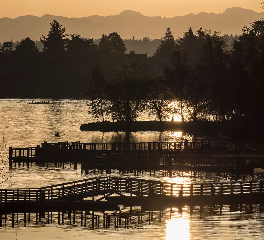
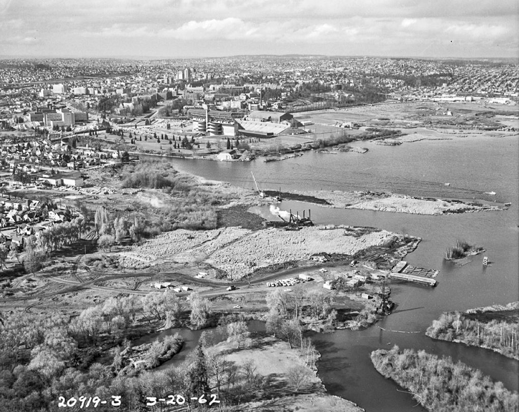
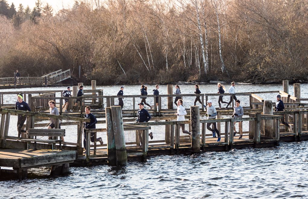
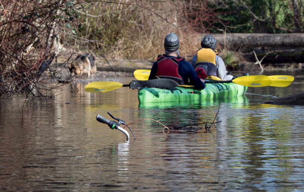 Given the litigations and unresolved tensions that have accompanied this project from its inception, it would not be wild to guess that more controversies will arise. Indeed, costly mistakes were made when the first new pontoons cracked and leaked, demolition of the old concrete structures spurred loud lawsuits over potential hazards and new bridge lighting irked those with lake views.
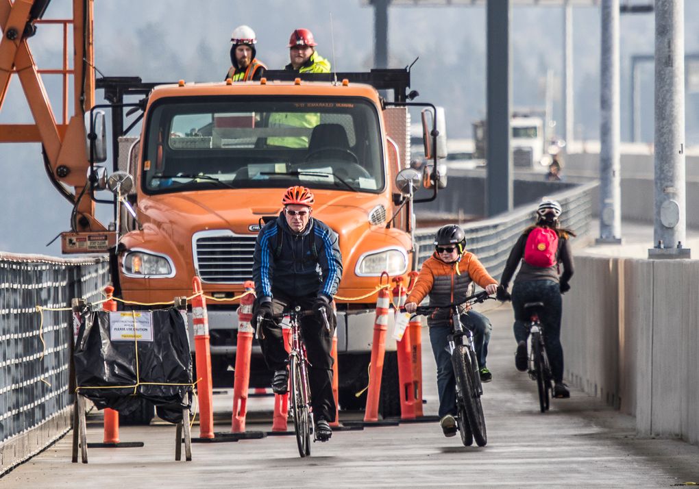


 Given the litigations and unresolved tensions that have accompanied this project from its inception, it would not be wild to guess that more controversies will arise. Indeed, costly mistakes were made when the first new pontoons cracked and leaked, demolition of the old concrete structures spurred loud lawsuits over potential hazards and new bridge lighting irked those with lake views.
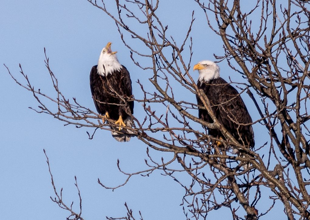


No comments:
Post a Comment